 Filter: Categories of Wisconsin Historical Images
Filter: County of Bayfield
Filter: Year of 1800-1899
Filter: Year of 1850-1859
Filter: Categories of Wisconsin Historical Images
Filter: County of Bayfield
Filter: Year of 1800-1899
Filter: Year of 1850-1859

| Date: | 1858 |
|---|---|
| Description: | Front cover of a guide book describing Bayfield and an account of a pleasure tour to Lake Superior. The title is surrounded by a decorative border with flo... |

| Date: | 1856 |
|---|---|
| Description: | This map of Bayfield shows a plat of the town, roads, and part of Lake Superior. Relief is shown by hachures. The right margin of the map includes illustra... |
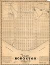
| Date: | 1858 |
|---|---|
| Description: | This map is a proposed plan for a town that was never built located in present day Bayfield county, showing street names and with numbered blocks and lots.... |

| Date: | 1856 |
|---|---|
| Description: | This map shows land ownership by name, a plat of Bayfield, local streets, part of Lake Superior, part of Madeline Island, and part of Bass Island. La Point... |
If you didn't find the material you searched for, our Library Reference Staff can help.
Call our reference desk at 608-264-6535 or email us at: