 Filter: Categories of Wisconsin Historical Images
Filter: County of Bayfield
Filter: Subject of water
Filter: Categories of Wisconsin Historical Images
Filter: County of Bayfield
Filter: Subject of water

| Date: | |
|---|---|
| Description: | Exterior of the menu for Paul's Cafe, with a bird's-eye view map of "Washburn's Natural Deep Water Land Locked Harbor," Chequamegon Bay, and the Apostle Is... |

| Date: | 1856 |
|---|---|
| Description: | This map shows land ownership by name, a plat of Bayfield, local streets, part of Lake Superior, part of Madeline Island, and part of Bass Island. La Point... |

| Date: | 1971 |
|---|---|
| Description: | A topgraphical map of Cable, Wisconsin showing railroads. |

| Date: | 1971 |
|---|---|
| Description: | A topographical map of Namekagon Lake and the surrounding area. |

| Date: | 07 2001 |
|---|---|
| Description: | David Obey poses with Park Ranger Geoffrey Smith on the left and Martin Hanson on the right. They are standing on the beach with water and land in the back... |

| Date: | |
|---|---|
| Description: | Three women stand on the shore in front of the steamer Barker at Devils Island natural dock. |
| Date: | 06 19 1958 |
|---|---|
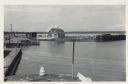
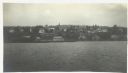
| Description: | Slightly elevated view of Cornucopia Harbor. There is a boat moored at a pier near a barn-shaped building. An automobile is parked on the far left. In the ... |
| Date: | 06 19 1958 |
|---|---|
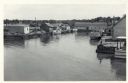
| Description: | Slightly elevated view over water towards East slip in Cornucopia Harbor. There is a small cluster of buildings along the left and right sides with boats m... |
| Date: | 06 19 1958 |
|---|---|
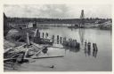
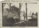
| Description: | View over water towards storm damage in Cornucopia Harbor. West slip. There is a pile of wood along the shoreline in the foreground, with a boat moored jus... |
| Date: | |
|---|---|
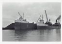
| Description: | View across water towards ships unloading coal and sulphur. Cranes rise above both ships, and a man is walking near a large pile of coal in the background ... |
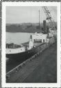
| Date: | |
|---|---|
| Description: | Elevated view over railroads tracks of Canadian ship with cargo of wood pulp. Sulphide bales are being unloaded and there are several men on the ship. In t... |
| Date: | |
|---|---|
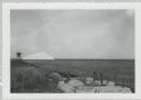
| Description: | View from shoreline of dock site towards Lake Superior, showing sulphur pile and a large chute in the background. |
| Date: | 1916 |
|---|---|
| Description: | View across Lake Superior towards Bayfield. |

| Date: | 1935 |
|---|---|
| Description: | This topographical map of the forest preserve shows highways, roads, trails, telephone lines, Native American reservations, Ranger sub-stations, state nurs... |

| Date: | 1918 |
|---|---|
| Description: | Manuscript map of the Chequamegon Bay area on Lake Superior drawn by Warren W. Witmer and illustrated with sketches by Mary L. Wright Witmer in ink and wat... |

| Date: | 2000 |
|---|---|
| Description: | This map shows national parks, county and state forests, Indian reservations, municipal land, private land, docks, boat access, camping, and points of inte... |

| Date: | 1929 |
|---|---|
| Description: | Aerial view of Lake Namakagon, showing the roads that connect Anderson Island (center left), and Juneks Point, Eagle Point, and Paines Island. |
| Date: | 11 29 1908 |
|---|---|
| Description: | Men working on pulling the boat "Fish Hawk" out of the water. One man is kneeling in front of the boat and looking at the camera. A man in the background i... |

| Date: | |
|---|---|
| Description: | Aerial view of the Pike Chain of Lakes near Iron River, Wisconsin. Caption reads: "Pike Chain of Lakes." Text on back reads: "The ideal vacationland for fi... |
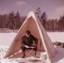
| Date: | |
|---|---|
| Description: | A man is sitting on a stool in the open doorway of a small tent on the ice on Lake Owen. He is holding a wooden drop line over a hole in the ice. Behind th... |
If you didn't find the material you searched for, our Library Reference Staff can help.
Call our reference desk at 608-264-6535 or email us at: