Filter: Categories of Wisconsin Historical Images
Filter: County of Bayfield
Filter: Subject of water
Filter: Creator Name of Unknown
Filter: Categories of Wisconsin Historical Images
Filter: County of Bayfield
Filter: Subject of water
Filter: Creator Name of Unknown
| Date: | |
|---|---|
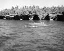
| Description: | Slightly elevated view of a wooden in-board motorboat on Lake Superior. Two men are in the front seat, and two bathing beauties are riding in the back wavi... |
| Date: | 1912 |
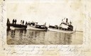
|---|---|
| Description: | Boats and people at the Bayfield dock on Labor Day 1912. Boats include Thelma; Lusitania; which later became a U.S. Mail boat; Captain Angus'... |
| Date: | 1904 |
|---|---|
| Description: | View across water towards Brower Park near Houghton Point. |
| Date: | |
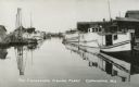
|---|---|
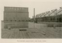
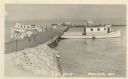
| Description: | Fishing Fleet in the harbor. Caption reads: "The Cornucopia Fishing Fleet, Cornucopia, Wis." |
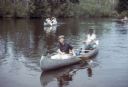
| Date: | 1966 |
|---|---|
| Description: | Gaylord Nelson participates in a canoe trip down the Namekagon River in an effort to protect the river under the National Wild and Scenic Rivers Act. |
| Date: | |
|---|---|
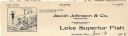
| Description: | Letterhead of Jacob Johnson & Company of Bayfield, Wisconsin, a wholesale dealer in fresh and saltwater Lake Superior Fish. Features a cartoon of a man wea... |
| Date: | |
|---|---|
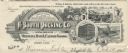
| Description: | Memohead of the A. Booth Packing Company of Bayfield, Wisconsin, dealing in "Oval Brand Oysters, Fish & Canned Goods," with a three-quarter view of the com... |

| Date: | 1858 |
|---|---|
| Description: | Front cover of a guide book describing Bayfield and an account of a pleasure tour to Lake Superior. The title is surrounded by a decorative border with flo... |

| Date: | 1935 |
|---|---|
| Description: | This pictorial map of northern Bayfield County, Wisconsin, shows the Chequamegon National Forest, the Red Cliff Indian Reservation, highways and roads, and... |

| Date: | 1967 |
|---|---|
| Description: | This tourist brochure for Bayfield County, Wisconsin, from 1967 includes a map of the county showing towns, cities and villages, highways and roads, railro... |

| Date: | 1920 |
|---|---|
| Description: | This manuscript map of southern Bayfield County, Wisconsin, covers the towns of Cable and Drummond and portions of Grandview and Namekagon. Shown are the t... |
| Date: | |
|---|---|
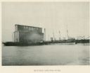
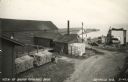
| Description: | Photographic postcard of an elevated view of the fishery and its dock. Caption reads: "View of Booth Fisheries Dock." |
| Date: | 1949 |
|---|---|
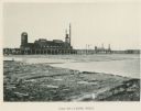
| Description: | Photographic postcard view of the City Dock on Lake Superior. There are four boats, and people and cars are on the dock. A sign in the foreground reads: "N... |

| Date: | |
|---|---|
| Description: | Exterior of the menu for Paul's Cafe, with a bird's-eye view map of "Washburn's Natural Deep Water Land Locked Harbor," Chequamegon Bay, and the Apostle Is... |

| Date: | 1856 |
|---|---|
| Description: | This map shows land ownership by name, a plat of Bayfield, local streets, part of Lake Superior, part of Madeline Island, and part of Bass Island. La Point... |

| Date: | 07 2001 |
|---|---|
| Description: | David Obey poses with Park Ranger Geoffrey Smith on the left and Martin Hanson on the right. They are standing on the beach with water and land in the back... |

| Date: | |
|---|---|
| Description: | Three women stand on the shore in front of the steamer Barker at Devils Island natural dock. |
If you didn't find the material you searched for, our Library Reference Staff can help.
Call our reference desk at 608-264-6535 or email us at: