 Filter: Categories of Wisconsin Historical Images
Filter: County of Bayfield
Filter: Subject of intellectual life
Filter: Categories of Wisconsin Historical Images
Filter: County of Bayfield
Filter: Subject of intellectual life

| Date: | 1886 |
|---|---|
| Description: | Bird's-eye view of Bayfield, county seat of Bayfield County. On the lower left side is an inset for Bayfield and the Apostle Islands. |

| Date: | 1886 |
|---|---|
| Description: | Bird's-eye map of Washburn on Lake Superior. There is an inset of Washburn, Chequamagon and the Apostle Islands. |

| Date: | 1896 |
|---|---|
| Description: | Bird's-eye view of Washburn, with twenty vignettes around side, water in foreground with docks and lumber corral. Thirty-three locations identified in key ... |

| Date: | 1910 |
|---|---|
| Description: | Bird's-eye view looking east, with Washburn Harbor at center and Chequamegon Bay in Lake Superior covering most of the upper image. Streets with buildings... |
| Date: | 1936 |
|---|---|
| Description: | Aerial view of Cable, in northern Wisconsin. Text at foot reads: "Airplane View of Cable, Wis. 244." |
| Date: | 1936 |
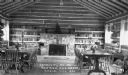
|---|---|
| Description: | Community room of the Library and Community Center. |
| Date: | |
|---|---|
| Description: | Photographic postcard of an aerial view of Lake Owen near Cable. Most of the lake is located within the Chequamegon National Forest. Caption reads: "Air Vi... |

| Date: | |
|---|---|
| Description: | Color postcard of an aerial view of the Lakewoods Family Resort on Lake Namekagon. All modern housekeeping cottages with an indoor heated swimming pool. |
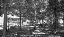
| Date: | 1937 |
|---|---|
| Description: | Three men, one woman and one child sit on lawn chairs and at a picnic table outside under the trees at Log Cabin Lodge on Lake Millicent. Three cabins are... |
| Date: | 1931 |
|---|---|
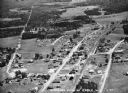
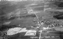
| Description: | Aerial view taken from an airplane overlooking the town of Mason. Farm fields, roads, trees, houses and other buildings are visible. |
| Date: | 1935 |
|---|---|
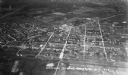
| Description: | Aerial view, taken from an airplane, overlooking the streets, houses, stores, trees and railroad cars. |
| Date: | |
|---|---|
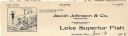
| Description: | Letterhead of Jacob Johnson & Company of Bayfield, Wisconsin, a wholesale dealer in fresh and saltwater Lake Superior Fish. Features a cartoon of a man wea... |
| Date: | |
|---|---|
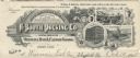
| Description: | Memohead of the A. Booth Packing Company of Bayfield, Wisconsin, dealing in "Oval Brand Oysters, Fish & Canned Goods," with a three-quarter view of the com... |

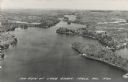
| Date: | 1937 |
|---|---|
| Description: | Aerial view of Lake Owen between Cable and Drummond. |

| Date: | 1858 |
|---|---|
| Description: | Front cover of a guide book describing Bayfield and an account of a pleasure tour to Lake Superior. The title is surrounded by a decorative border with flo... |

| Date: | 1930 |
|---|---|
| Description: | View from the dirt road of front of a one-story log building with a brick chimney. In the foreground are a chain link fence, gate, and shrubs. This buildin... |
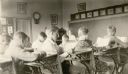
| Date: | 1931 |
|---|---|
| Description: | Students of the Miles School, Bayfield County District No. 2, read at their desks supervised by their teacher, Mrs. Inez Lindell Bystrom. There is a parlor... |

| Date: | |
|---|---|
| Description: | Exterior of the menu for Paul's Cafe, with a bird's-eye view map of "Washburn's Natural Deep Water Land Locked Harbor," Chequamegon Bay, and the Apostle Is... |
If you didn't find the material you searched for, our Library Reference Staff can help.
Call our reference desk at 608-264-6535 or email us at:

