Filter: Categories of Wisconsin Historical Images
Filter: County of Bayfield
Filter: Subject of church buildings
Filter: Categories of Wisconsin Historical Images
Filter: County of Bayfield
Filter: Subject of church buildings

| Date: | 1886 |
|---|---|
| Description: | Bird's-eye view of Bayfield, county seat of Bayfield County. On the lower left side is an inset for Bayfield and the Apostle Islands. |

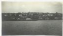
| Date: | 1896 |
|---|---|
| Description: | Bird's-eye view of Washburn, with twenty vignettes around side, water in foreground with docks and lumber corral. Thirty-three locations identified in key ... |

| Date: | 1910 |
|---|---|
| Description: | Bird's-eye view looking east, with Washburn Harbor at center and Chequamegon Bay in Lake Superior covering most of the upper image. Streets with buildings... |
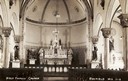
| Date: | |
|---|---|
| Description: | Interior view of the Holy Family Church. Caption reads: "Holy Family Church, Bayfield, Wis." |
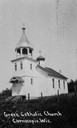
| Date: | 1920 |
|---|---|
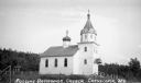
| Description: | Exterior of Russian Orthodox Church. Caption reads: "Greek Catholic Church, Cornucopia, Wis." |

| Date: | 1920 |
|---|---|
| Description: | Interior view of three-tiered altar, with gilded ornamentation surrounding it, two candlesticks, and several paintings on the walls. |
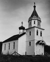
| Date: | 1948 |
|---|---|
| Description: | Exterior of St. Mary's Russian Orthodox Church. |
| Date: | |
|---|---|
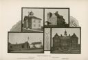
| Description: | A composite photograph of four views of Washburn, including Pioneer School, St. Louis Catholic Church and School, Lincoln School, and Garfield School. |
| Date: | 1904 |
|---|---|
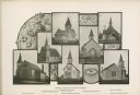
| Description: | Composite photograph of views of seven Washburn churches, including Mehtodist Church, Swedish Mission Church, Congregational Church, Norwegian Lutheran Chu... |
| Date: | 1937 |
|---|---|
| Description: | Exterior of the Russian Orthodox Church, a white clapboard building with onion dome detail on the roof. |
| Date: | 1937 |
|---|---|
| Description: | Exterior view of white clapboard church with a bell tower and stained glass windows. |
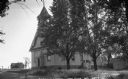
| Date: | 1935 |
|---|---|
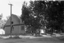
| Description: | Catholic Church with a bell tower. |
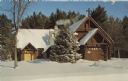
| Date: | |
|---|---|
| Description: | Color postcard of Trinity Lutheran Church. It is a log chapel, built of native timber, and designed to fit the Northwoods area. |

| Date: | 1930 |
|---|---|
| Description: | Exterior view of the Roman Catholic Church. It is a one-story wood, rectanglular building with a bell tower above the front entrance. There is snow on the ... |

| Date: | 1931 |
|---|---|
| Description: | Exterior three-quarter view from road showing the front entrance, with belfry, and a steeple with a large cross at the peak of the roof. There is a large t... |

| Date: | 1936 |
|---|---|
| Description: | Exterior view of a log church showing the front doorway and entry way and the left side of the building. There is a stone chimney at the back near another ... |

| Date: | 1900 |
|---|---|
| Description: | This 1900 map shows the township and range system, sections, cities and villages, railroads, roads, vacant land and land sold by the Wisconsin Central Rail... |

| Date: | 1950 |
|---|---|
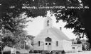
| Description: | Photographic postcard of a white painted, wood frame Immanuel Lutheran Church. Sign out front. Sent Sept. 15, 1965, to thank visitors from Eau Claire for c... |
| Date: | 1916 |
|---|---|
| Description: | View across Lake Superior towards Bayfield. |
If you didn't find the material you searched for, our Library Reference Staff can help.
Call our reference desk at 608-264-6535 or email us at: