 Filter: Categories of Wisconsin Historical Images
Filter: County of Ashland
Filter: Year of 1900-1999
Filter: Year of 1980-1989
Filter: Categories of Wisconsin Historical Images
Filter: County of Ashland
Filter: Year of 1900-1999
Filter: Year of 1980-1989

| Date: | 12 15 1981 |
|---|---|
| Description: | Project ELF activist Jerry Holter (left) and John Lavine, head of the Lavine Newspaper Groups based in Chippewa Falls, outside the Clam Lake facilities of ... |

| Date: | 12 15 1981 |
|---|---|
| Description: | Captain Charles Biele and an unidentified staffer in the Navy facility at Clam Lake known as Project ELF. |

| Date: | 12 15 1981 |
|---|---|
| Description: | Captain Charles Biele and an unidentified staffer inside the Navy's facility at Clam Lake known as Project ELF. |

| Date: | 12 15 1981 |
|---|---|
| Description: | John A. Lavine of Chippewa Falls, head of the Lavine Newspaper Group and publisher of several Wisconsin newspapers. |
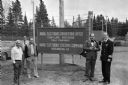
| Date: | 12 15 1981 |
|---|---|
| Description: | Captain Charles Biele (right) and John A. Lavine (next to Biele), Wisconsin newspaper publisher, before Lavine toured the controversial U.S. Navy facility ... |

| Date: | 1981 |
|---|---|
| Description: | Plat map of Madeline Island surrounded by Basswood, Michigan and Gull Islands. |

| Date: | 1989 |
|---|---|
| Description: | At the dedication of the Blue Cross/Blue Shield facilty, Congressman David R. Obey was present to present a flag that had flown over the United States Capi... |

| Date: | 1988 |
|---|---|
| Description: | Congressman David Obey and his wife Joan on Martin Hanson's pontoon. He was a good friend of the Obeys and was inducted into the Wisconsin Conservation Hal... |

| Date: | 1980 |
|---|---|
| Description: | This map shows the locations of 42 businesses, roads, points of interest, recreation sites, camping, the North Country Trail and parking, and boundaries of... |

| Date: | 1985 |
|---|---|
| Description: | This map shows mining, White River, Silver Creek, Bad River, Agogic Lake, Chequamegon Bay, smaller lakes, the Bad River Indian Reservation, and communities... |
If you didn't find the material you searched for, our Library Reference Staff can help.
Call our reference desk at 608-264-6535 or email us at: