Filter: Categories of Wisconsin Historical Images
Filter: County of Ashland
Filter: Year of 1900-1999
Filter: Year of 1950-1959
Filter: Categories of Wisconsin Historical Images
Filter: County of Ashland
Filter: Year of 1900-1999
Filter: Year of 1950-1959
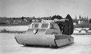
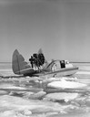
| Date: | 05 1954 |
|---|---|
| Description: | Windsled used to transport passengers and goods between Madeline Island and Bayfield. This image was in Ross' book, "La Pointe: Village Outpost". |
| Date: | 1955 |
|---|---|
| Description: | This was the first boat & sled-type wind sled built on Madeline Island. Built by Elmer Nelson for Howard Russell between 1950-1951. Had a 9-cylinder R-680-... |
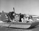
| Date: | 1954 |
|---|---|
| Description: | Elmer Nelson sorting through boxes of goods being transported on the "Dream Sled" windsled. |
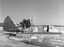
| Date: | 1953 |
|---|---|
| Description: | This was the first boat & sled-type windsled built on Madeline Island. Built by Elmer Nelson for Howard Russell between 1950-1951. Had a 9-cylinder R-680-E... |
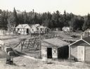
| Date: | 1956 |
|---|---|
| Description: | Constructing the Madeline Island Historical Museum in La Pointe which consists of four separate buildings. L-to-r: jail; American Fur Trade storage buildin... |
| Date: | 1955 |
|---|---|
| Description: | Wheeler Hall at Northland College, during winter. A group of people are on a bridge over the Bay City Creek, surrounded by trees, in the foreground. Wheele... |
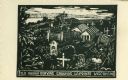
| Date: | 1959 |
|---|---|
| Description: | Caption reads: "Old Indian Burying Grounds LaPointe Wisconsin." |
| Date: | 1950 |
|---|---|
| Description: | Elevated view of land operations of commercial fishing operation with fish net drying reels and buildings on Apostle Islands. |
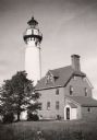
| Date: | 1950 |
|---|---|
| Description: | Lighthouse on Outer Island of the Apostle Islands. |
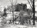
| Date: | 1958 |
|---|---|
| Description: | The Madeline Island Historical Museum behind a "pencil" designed fence. |
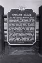
| Date: | 08 1959 |
|---|---|
| Description: | Madeline Island Sign (Wisconsin Official Marker) depicting the history of the island and how it recieved its name. This sign was erected in 1956. |
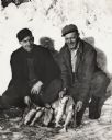
| Date: | 1950 |
|---|---|
| Description: | Vern Frechette (left) and Leonard Larson show their catch of trout caught during ice fishing on Chequamegon Bay. |

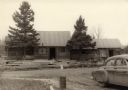
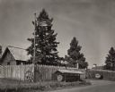
| Date: | 06 15 1950 |
|---|---|
| Description: | View of outhouses in a wooded area. |

| Date: | 1952 |
|---|---|
| Description: | This 1952 map shows the trails, roads, and railroads through the counties of Ashland, Bayfield, Sawyer, Price, Iron, and Vilas. Also shown are lakes, river... |

| Date: | 1956 |
|---|---|
| Description: | This map shows the types of upland and lowland forest vegetation on Stockton Island, one of the Apostle Islands in Lake Superior. |

| Date: | 1951 |
|---|---|
| Description: | This map shows Ashland and Washburn harbors in shades of blue and yellow. Water depths shown by isolines and soundings, and relief is shown by contours. Th... |

| Date: | 1959 |
|---|---|
| Description: | This map shows landownership, acreages, and old fort road on the southwest corner of Madeline Island. The map includes an explanation of survey in the midd... |
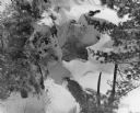
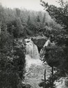
| Date: | 1950 |
|---|---|
| Description: | Snow and ice cover the upper portion of Copper Falls. There is also open water in the Bad River downstream from the falls. |
If you didn't find the material you searched for, our Library Reference Staff can help.
Call our reference desk at 608-264-6535 or email us at: