 Filter: Categories of Wisconsin Historical Images
Filter: County of Ashland
Filter: Year of 1800-1899
Filter: Subject of land
Filter: Categories of Wisconsin Historical Images
Filter: County of Ashland
Filter: Year of 1800-1899
Filter: Subject of land
| Date: | 1890 |
|---|---|
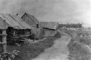
| Description: | Three men sitting in front of log building at Big Bay Beach on Madeline Island. |
| Date: | 1897 |
|---|---|
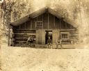
| Description: | Dirt trail passing log shack that was probably the home of Michael and Madeline Cadotte. |

| Date: | 1886 |
|---|---|
| Description: | Bird's-eye view of Ashland, on the shores of Lake Superior, with insets of The Apostle Islands Chequamagon Bay & Ashland, and Distances from Ashland. |

| Date: | 1898 |
|---|---|
| Description: | Old Mission Residence at La Pointe, Madeline Island. |

| Date: | 1890 |
|---|---|
| Description: | Bird's-eye map of Ashland, viewed from Lake Superior, with insets of Prentice Park and Fishery. Population 16,000. Increase in Ten Years, 11,000. |

| Date: | 02 26 1887 |
|---|---|
| Description: | Bird's-eye map of Ashland, and the Apostle Islands in Lake Superior. Caption reads: "Ashland and the Apostle Islands." |
| Date: | 1885 |
|---|---|
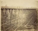
| Description: | Elevated view of the Wiscsonsin Central's bridge over the White River, about six miles south of Ashland. The bridge was 1600 ft. long and 110 ft. above the... |
| Date: | 1870 |
|---|---|
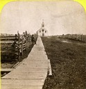
| Description: | Boardwalk leading to St. Joseph's Catholic Church in La Pointe. |

| Date: | 1884 |
|---|---|
| Description: | Panorama bird's-eye view of the town of Ashland, on Lake Superior, and the Apostle Islands. |
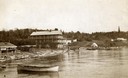
| Date: | 1890 |
|---|---|
| Description: | Old Mission Inn and boats on shoreline of Lake Superior on Madeline Island. The Old Mission Inn had numerous modifications over the years. It was razed in... |
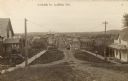
| Date: | 1895 |
|---|---|
| Description: | Looking down unpaved North Grand street, which appears to be the main street of Glidden, Wisconsin. Caption reads: "N. Grand St. Glidden Wis." |

| Date: | 1842 |
|---|---|
| Description: | American Fur Company with both Mission churches. Sketch purportedly by a Native American youth. Probably an overpainted photographic copy enlargement. Pape... |
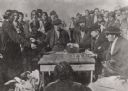
| Date: | 1870 |
|---|---|
| Description: | Indians receiving payment. Seated on the right is John W. Bell. Others are, left to right, Asaph Whittlesey, Agent Henry C. Gilbert, and William S. Warren ... |
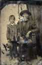
| Date: | 1854 |
|---|---|
| Description: | Tintype of Michael De Perry and unidentified child. |

| Date: | 1834 |
|---|---|
| Description: | This copy of an 1834 map in the American Fur Company's papers held by the New-York Historical Society shows an outline of Chequamegon Bay and Madeline Isla... |

| Date: | 1887 |
|---|---|
| Description: | This 1887 map of Ashland County, Wisconsin, shows the township and range system, sections, railroads, vacant Wisconsin Central Railroad land, state and "go... |

| Date: | 1896 |
|---|---|
| Description: | This 1896 map shows the township and range system, sections, cities and villages, railroads, roads, vacant land and land sold by the Wisconsin Central Rail... |

| Date: | 1896 |
|---|---|
| Description: | This 1898 map shows the township and range system, sections, cities and villages, railroads, roads, vacant land and land sold by the Wisconsin Central Rail... |

| Date: | 1890 |
|---|---|
| Description: | This map shows the Wisconsin Central Railroad land grant lands owned and for sale by the Soo Line in Ashland County, Wisconsin, as well as in portions of B... |

| Date: | 1886 |
|---|---|
| Description: | This map of Ashland County, Wisconsin, which at the time included part of present-day Iron County, also covers portions of Vilas County, Wisconsin, then pa... |
If you didn't find the material you searched for, our Library Reference Staff can help.
Call our reference desk at 608-264-6535 or email us at: