 Filter: Categories of Wisconsin Historical Images
Filter: County of Ashland
Filter: Subject of wetlands
Filter: Categories of Wisconsin Historical Images
Filter: County of Ashland
Filter: Subject of wetlands

| Date: | 1898 |
|---|---|
| Description: | This 1898 map of Ashland County, Wisconsin, shows the township and range grid, towns, sections, cities and villages, landownership, roads, railroads, swamp... |

| Date: | 1964 |
|---|---|
| Description: | This 1964 map of Madeline Island, Ashland County, Wisconsin, shows existing and historical locations, roads, the boundaries of a proposed state park, secti... |
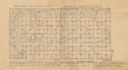
| Date: | 1859 |
|---|---|
| Description: | Shows acreages and swamps in a portion of Gordon township, Ashland County, Wis. Originally published as two maps. Township lines surveyed by A.C. Stuntz ; ... |
If you didn't find the material you searched for, our Library Reference Staff can help.
Call our reference desk at 608-264-6535 or email us at: