 Filter: Categories of Wisconsin Historical Images
Filter: County of Ashland
Filter: Subject of transportation
Filter: Subject of lakes
Filter: Categories of Wisconsin Historical Images
Filter: County of Ashland
Filter: Subject of transportation
Filter: Subject of lakes
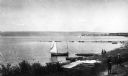
| Date: | 1900 |
|---|---|
| Description: | Elevated view of La Pointe and the shoreline from the Old Mission dock. Two boys and two men stand along the shoreline. The white building with the dark ro... |
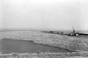
| Date: | 1936 |
|---|---|
| Description: | Elevated view of logs tugged across Lake Superior to the harbor at Ashland. |

| Date: | |
|---|---|
| Description: | Looking West from Knight Block, with shipping piers and sailing ships on right side, railroad on left, trees in background. Horse-drawn carriages on street... |
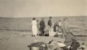
| Date: | 1925 |
|---|---|
| Description: | Group of eight adults getting in or out of a boat on an Apostle Island beach. |
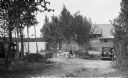
| Date: | 1937 |
|---|---|
| Description: | Gas pump and automobile next to a tavern on county Road D near Clam Lake. |
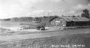
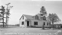
| Date: | 1938 |
|---|---|
| Description: | Elevated view of Melody Haven Tavern near Clam Lake. A man is standing next to a stone wall surrounding a parking lot. |
| Date: | 1935 |
|---|---|
| Description: | View from hill of wooden row boats pulled on shore of two-story log cabin belonging to Dr. Bengston on White Bass Lake near Clam Lake. |
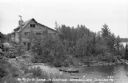
| Date: | 1934 |
|---|---|
| Description: | A German shepherd is laying in the yard of a two-story log cabin belonging to Dr. Bengston on White Bass Lake. There are two cars parked in the yard. |
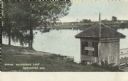
| Date: | 05 29 |
|---|---|
| Description: | Colorized postcard of Butternut Lake in the spring, with a pier and latticed boathouse. The opposite shore has trees and foliage. Text below reads: "Spring... |

| Date: | 1934 |
|---|---|
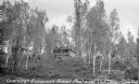
| Description: | View down hill of a tavern, with signs advertising "Budweiser" and "Beer," on the shores of Clam Lake. There are numerous outbuildings and two automobiles ... |
| Date: | 1935 |
|---|---|
| Description: | View from lake up hill of two wooden cabins. Nearby is an automobile, stairs to the beach, and some boats on the shoreline at Buehlow's Resort on Partridge... |

| Date: | 1939 |
|---|---|
| Description: | This map shows the towns to Gingles, Sanborn, and Guney as well as Chequamegon Bay, Kakagon River, White River, Marengo River, Bad River, Potato River, Vau... |

| Date: | 1952 |
|---|---|
| Description: | This 1952 map shows the trails, roads, and railroads through the counties of Ashland, Bayfield, Sawyer, Price, Iron, and Vilas. Also shown are lakes, river... |

| Date: | 1887 |
|---|---|
| Description: | This 1887 map of Ashland County, Wisconsin, shows the township and range system, sections, railroads, vacant Wisconsin Central Railroad land, state and "go... |

| Date: | 1896 |
|---|---|
| Description: | This 1896 map shows the township and range system, sections, cities and villages, railroads, roads, vacant land and land sold by the Wisconsin Central Rail... |

| Date: | 1896 |
|---|---|
| Description: | This 1898 map shows the township and range system, sections, cities and villages, railroads, roads, vacant land and land sold by the Wisconsin Central Rail... |

| Date: | 1925 |
|---|---|
| Description: | This 1925 map of Ashland County, Wisconsin, shows the township and range system, towns, sections, cities and villages, the Bad River Indian Reservation, ra... |

| Date: | 1890 |
|---|---|
| Description: | This map shows the Wisconsin Central Railroad land grant lands owned and for sale by the Soo Line in Ashland County, Wisconsin, as well as in portions of B... |

| Date: | 1886 |
|---|---|
| Description: | This map of Ashland County, Wisconsin, which at the time included part of present-day Iron County, also covers portions of Vilas County, Wisconsin, then pa... |

| Date: | 1890 |
|---|---|
| Description: | This 1890s map shows the Wisconsin Central Railroad land grant lands owned and for sale by the Soo Line in Ashland County, Wisconsin, as well as in the eas... |
If you didn't find the material you searched for, our Library Reference Staff can help.
Call our reference desk at 608-264-6535 or email us at: