 Filter: Categories of Wisconsin Historical Images
Filter: County of Ashland
Filter: Subject of transportation
Filter: Subject of formations (geology)
Filter: Categories of Wisconsin Historical Images
Filter: County of Ashland
Filter: Subject of transportation
Filter: Subject of formations (geology)
| Date: | |
|---|---|
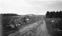
| Description: | Looking east at Terminal Moraine topography. View is down a dirt road with a house in the near background. |
| Date: | 1935 |
|---|---|
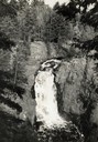
| Description: | Elevated view of the Brownstone Falls on the Bad River. |
| Date: | 1934 |
|---|---|
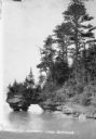
| Description: | View across water of sandstone cliff shoreline along Lake Superior at the Apostle Islands. On the far right a boat is pulled up onshore, and painted on the... |

| Date: | 09 04 1885 |
|---|---|
| Description: | Exterior and interior bill of fare from The Chequamegon, with views on the back of rock formations, waterfalls, a spot illustration of a train going over a... |

| Date: | 1886 |
|---|---|
| Description: | This map shows north and south ore veins, landownership, railroads, rivers, and township grid in parts of Ashland County, Wis. and Ontonagon County, Mich. ... |
| Date: | 1920 |
|---|---|
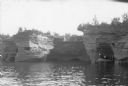
| Description: | View across water towards three men and a woman posing while standing in a wooden boat in a sea cave in the Apostle Islands. Rock formations and other sea ... |
If you didn't find the material you searched for, our Library Reference Staff can help.
Call our reference desk at 608-264-6535 or email us at: