Filter: Categories of Wisconsin Historical Images
Filter: County of Ashland
Filter: Subject of outdoor photography
Filter: Categories of Wisconsin Historical Images
Filter: County of Ashland
Filter: Subject of outdoor photography
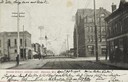
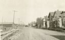
| Date: | 04 30 1907 |
|---|---|
| Description: | Text on front reads: "Second Street, Looking East, Ashland, Wis." An unpaved street with two sets of streetcar tracks in the center. Buildings, storefronts... |
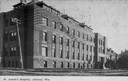
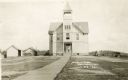
| Date: | 1905 |
|---|---|
| Description: | Caption reads: "St. Joseph's Hospital, Ashland, Wis." Front facade and grounds of the four-story, red brick hospital built in 1905. The basement level is b... |

| Date: | 08 14 1932 |
|---|---|
| Description: | The watershed sign unveiled. The marker is 39 miles south of Ashland adjacent to Highway 13, 2 miles north of Gordon Lake. |

| Date: | 08 14 1932 |
|---|---|
| Description: | Watershed sign unveiled with ceremony participants. The marker is 39 miles south of Ashland adjacent to Highway 13, 2 miles north of Gordon Lake. |
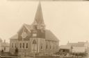
| Date: | 1910 |
|---|---|
| Description: | Front view of Evangelical Church with neighboring houses. |
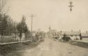
| Date: | 1910 |
|---|---|
| Description: | View down unpaved East Main Street, with lumber stacked along the roadside on the left, and on the right storefronts are lining the street. A horse-drawn v... |
| Date: | 1910 |
|---|---|
| Description: | Front entrance to the public school in Butternut. A wooden sidewalk leads up to the entrance, where a |
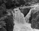
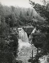
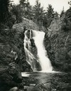
| Date: | |
|---|---|
| Description: | Elevated view of the falls. There are three men at the top of the falls. |
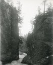
| Date: | 1929 |
|---|---|
| Description: | The gorge of the Bad River below Brownstone Falls. |
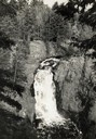
| Date: | 1935 |
|---|---|
| Description: | View from rocky shoreline towards the Brownstone Falls in Copper Falls State Park. |
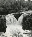
| Date: | 1935 |
|---|---|
| Description: | Elevated view of the Brownstone Falls on the Bad River. |
| Date: | 1937 |
|---|---|
| Description: | Elevated view of the waterfall where the Bad River tumbles over the Keweenawan Trap Ledge. |
| Date: | 1910 |
|---|---|
| Description: | View of Main Street when it was a dirt road. A church is in the background, and telephone poles are along the left side of the road. A streetlight is hangi... |
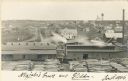
| Date: | 1906 |
|---|---|
| Description: | Elevated view of a sawmill and the distant town in the background. Stacks of logs are in the lumberyard. Along the bottom is a New Year's greeting in Germa... |
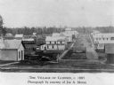
| Date: | 1885 |
|---|---|
| Description: | View of buildings in an industrial area with a forest in the background. |

| Date: | 1902 |
|---|---|
| Description: | Slightly elevated view looking down Main Street, with people walking on the wooden sidewalks, horse and carriages driving down the street and storefronts w... |

| Date: | 1905 |
|---|---|
| Description: | View down road, with homes in a residential area, and a church building in the foreground on the right. The sign above the church door reads: "E. V. Luth. ... |
If you didn't find the material you searched for, our Library Reference Staff can help.
Call our reference desk at 608-264-6535 or email us at: