 Filter: Categories of Wisconsin Historical Images
Filter: County of Ashland
Filter: Community of Ashland
Filter: Categories of Wisconsin Historical Images
Filter: County of Ashland
Filter: Community of Ashland

| Date: | 1888 |
|---|---|
| Description: | This map shows wards and includes the Chequamegon Bay and Washburn. An inset map shows the Ashland region, its railroads, and a few of its iron mines. |

| Date: | 1900 |
|---|---|
| Description: | This map is shows land in white and water in blue and is indexed for parks, points of interest, schools, churches, and recreational areas. The map shows lo... |

| Date: | 1924 |
|---|---|
| Description: | This map is pen, pencil, and watercolor on paper and shows land ownership by name, local streets, railroads, and part of Chequamegon Bay. The map includes ... |

| Date: | 1900 |
|---|---|
| Description: | This map is pencil and ink on tracing cloth and shows local streets, railroads, harbor line, and part of Chequamegon Bay. |

| Date: | 06 1923 |
|---|---|
| Description: | Sanborn map of Ashland, which includes Chequamegon Bay. |
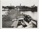
| Date: | 09 14 1962 |
|---|---|
| Description: | View from pier, lined with rocks, towards town. There are industrial buildings along the shoreline, and up a small rise is a building with a tower, and on ... |
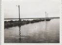
| Date: | 09 14 1962 |
|---|---|
| Description: | View across water towards jetty and dock, with three lampposts, from south east. |
| Date: | |
|---|---|
| Description: | Outdoor group portrait of seven female students at Northland College. A few of the women are holding donuts, and a woman in the center is getting ready to ... |

| Date: | 1985 |
|---|---|
| Description: | This map shows mining, White River, Silver Creek, Bad River, Agogic Lake, Chequamegon Bay, smaller lakes, the Bad River Indian Reservation, and communities... |
| Date: | |
|---|---|
| Description: | Man sitting at the aft of a canoe in a wooded river area. There is an outboard motor leaning against a tree in the center of the image. Handwritten text ca... |
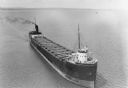
| Date: | 1935 |
|---|---|
| Description: | Aerial view of crew members standing and sitting on the deck of the ore boat Captain Thomas Wilson in Ashland harbor. |
| Date: | 1935 |
|---|---|
| Description: | View from shoreline towards three ore boats at the Soo Line Railroad dock being loaded with iron ore. The first in line is the William B. Pilkey. |

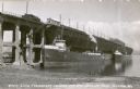
| Date: | 1895 |
|---|---|
| Description: | Stereograph of the side cliff view of the railroad White River bridge, showing the support beams and river underneath. It is six miles south of Ashland. Th... |
| Date: | 06 19 1890 |
|---|---|
| Description: | Studio portrait in front of a painted backdrop of a woman and man posing together. The man is sitting in a chair holding a hat and an umbrella. The woman i... |

| Date: | 1930 |
|---|---|
| Description: | A child is holding out a bowl to a pillar from which water is cascading down into a spring. In the background, two other children are walking up a dirt pat... |
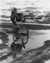
| Date: | 1978 |
|---|---|
| Description: | A girl is riding her bike through a puddle created by melting snow. She is holding her feet up off the pedals, away from the splashing water. |

| Date: | 1950 |
|---|---|
| Description: | Copper Falls plunging over rocks on the Bad River in Copper Falls State Park. |
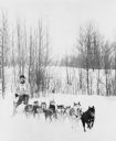
| Date: | 1978 |
|---|---|
| Description: | A musher on a dogsled with 10 dogs pulling in tandem. This is a race because he is wearing a number. Low hills with trees are in the background. |
If you didn't find the material you searched for, our Library Reference Staff can help.
Call our reference desk at 608-264-6535 or email us at:
