Filter: Categories of Wisconsin Historical Images
Filter: County of Ashland
Filter: Type of Photograph
Filter: Categories of Wisconsin Historical Images
Filter: County of Ashland
Filter: Type of Photograph

| Date: | 1929 |
|---|---|
| Description: | View of an ore dock on Chequamegon Bay. Buildings on the shore of the bay can be seen, however, not the water. |
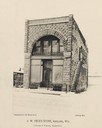
| Date: | 1890 |
|---|---|
| Description: | Front view of G.W. Peck's Store. The ground is covered with snow. The signs on the building read "Globe Steam Laundry" and the text below the photograph re... |

| Date: | 1930 |
|---|---|
| Description: | Six girls sit on a stone wall beside Mammoth Spring in Prentice Park. |
| Date: | 1931 |
|---|---|
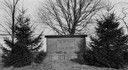
| Description: | View of the Radisson-Groseilliers house historic site marker in the vicinity of Ashland. The marker was unveiled at the mouth of Fish Creek on October 25, ... |

| Date: | 08 14 1932 |
|---|---|
| Description: | Front row: W.E. Dillon, County Highway Commissioner of Ashland; Andrew Good of Gordon Lake at Glidden; Patsy Winter of Ashland and Leo Jerome Driscoll, unv... |
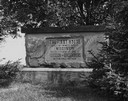
| Date: | 1935 |
|---|---|
| Description: | Close-up of the Radisson and Groseilliers house historic site marker, commemorating the first house built in Wisconsin by white men. The house was believed... |
| Date: | 1936 |
|---|---|
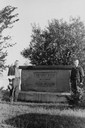
| Description: | View of two men posing on either side of the Radisson and Groseilliers House historical marker. The house was the first built by white men in Wisconsin and... |
| Date: | 1944 |
|---|---|
| Description: | View of the Radisson and Groseilliers marker at the site of the first house built by white men in Wisconsin. The marker is located in the vicinity of Ashla... |
| Date: | 1900 |
|---|---|
| Description: | Railway passenger depot in Ashland (?), Wisconsin. |

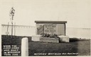
| Date: | 08 14 1932 |
|---|---|
| Description: | The watershed sign unveiled. The marker is 39 miles south of Ashland adjacent to Highway 13, 2 miles north of Gordon Lake. |

| Date: | 08 14 1932 |
|---|---|
| Description: | Watershed sign unveiled with ceremony participants. The marker is 39 miles south of Ashland adjacent to Highway 13, 2 miles north of Gordon Lake. |
| Date: | 1910 |
|---|---|
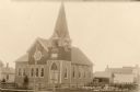
| Description: | Front view of Evangelical Church with neighboring houses. |
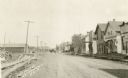
| Date: | 1910 |
|---|---|
| Description: | View down unpaved East Main Street, with lumber stacked along the roadside on the left, and on the right storefronts are lining the street. A horse-drawn v... |
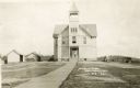
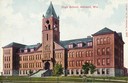
| Date: | 1910 |
|---|---|
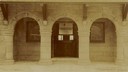
| Description: | Front entrance to the public school in Butternut. A wooden sidewalk leads up to the entrance, where a |
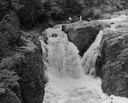
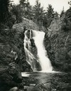
| Date: | |
|---|---|
| Description: | Elevated view of the falls. There are three men at the top of the falls. |
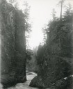
| Date: | 1929 |
|---|---|
| Description: | The gorge of the Bad River below Brownstone Falls. |
| Date: | 1935 |
|---|---|
| Description: | View from rocky shoreline towards the Brownstone Falls in Copper Falls State Park. |
If you didn't find the material you searched for, our Library Reference Staff can help.
Call our reference desk at 608-264-6535 or email us at: