Filter: Categories of Wisconsin Historical Images
Filter: County of Adams
Filter: Subject of transportation
Filter: Year of 1900-1999
Filter: Categories of Wisconsin Historical Images
Filter: County of Adams
Filter: Subject of transportation
Filter: Year of 1900-1999
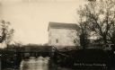
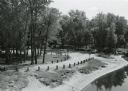
| Date: | 1914 |
|---|---|
| Description: | View of a mill on the bank of a river, and an adjacent dam. Caption at bottom reads: "Scene At Picturesque Friendship, Wis." |

| Date: | 1986 |
|---|---|
| Description: | Panoramic view of the intersection of County Z and F, looking east from Z. The view shows several rural bars and restaurants. |

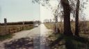
| Date: | 1987 |
|---|---|
| Description: | Panoramic view of the intersection of county highways Z (15th Avenue) and D in rural Adams County, looking east and south to a bar at the corner. |
| Date: | 09 20 1972 |
|---|---|
| Description: | Wayside #8 near Necedah in rural Adams County. |
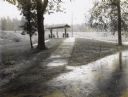
| Date: | 09 30 1970 |
|---|---|
| Description: | Point Bluff Wayside as viewed from the highway bridge above. |
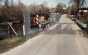
| Date: | 05 02 1985 |
|---|---|
| Description: | Bridge over Duck Creek in the Town of Adams, Adams County, Wisconsin. |
| Date: | 05 02 1985 |
|---|---|
| Description: | Bridge over White Creek in the Town of Easton, Adams County, Wisconsin. |
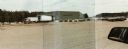
| Date: | 03 21 1986 |
|---|---|
| Description: | Office and metal warehouse of Potato World, Inc., located on County Highway E near Grand Marsh in Adams County. |

| Date: | 1935 |
|---|---|
| Description: | View from Highway 13 of Olin Cabins, with a car in driveway. |
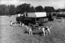
| Date: | 1990 |
|---|---|
| Description: | Six dogs are tied up near a parked pickup truck at Folk Fest. |

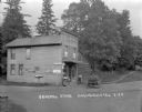
| Date: | 1990 |
|---|---|
| Description: | "Tanknology" employee inspecting gasoline at "Cenex" gas station. |

| Date: | 1990 |
|---|---|
| Description: | Young contestants are at their marks for a miniature tractor race. |
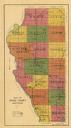
| Date: | 1916 |
|---|---|
| Description: | This early 20th century map of Adams County, Wisconsin, shows the township and range grid, towns, sections, cities and villages, roads, railroads, lakes an... |
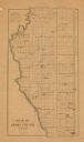
| Date: | 1900 |
|---|---|
| Description: | This map of Adams County, Wisconsin, from E.B. Foote's Plat book of Adams County, Wisconsin, 1900, shows the township and range grid, towns, sections, citi... |
| Date: | 1922 |
|---|---|
| Description: | View from road of the general store, a two-story wood frame building in a rural area. A man and a child are standing near the door. Another child is sittin... |

| Date: | 1928 |
|---|---|
| Description: | View down slope towards Deep Lake. There is a girl standing in a rowboat at the shoreline. She is holding up her catch of the day. In the background a man ... |

| Date: | 1930 |
|---|---|
| Description: | View across lawn of long grass towards a log cabin next to the Wisconsin River. An automobile is parked on the left near the porch. |

| Date: | 1908 |
|---|---|
| Description: | View of Main Street in Friendship. The J.Hill & Son General Store is on the right, with two women at the entrance. Horse-drawn vehicles are in the street. |
If you didn't find the material you searched for, our Library Reference Staff can help.
Call our reference desk at 608-264-6535 or email us at: