 Filter: Categories of Wisconsin Historical Images
Filter: County of Adams
Filter: Subject of transportation
Filter: Subject of cities and towns
Filter: Categories of Wisconsin Historical Images
Filter: County of Adams
Filter: Subject of transportation
Filter: Subject of cities and towns
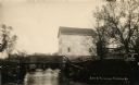
| Date: | 1914 |
|---|---|
| Description: | View of a mill on the bank of a river, and an adjacent dam. Caption at bottom reads: "Scene At Picturesque Friendship, Wis." |

| Date: | |
|---|---|
| Description: | A crowd of people looking toward the camera has gathered in front of the Rome Post Office that has a folded-up awning and a flag over the entrance. A pathw... |

| Date: | 1990 |
|---|---|
| Description: | "Tanknology" employee inspecting gasoline at "Cenex" gas station. |
| Date: | |
|---|---|
| Description: | Photographic postcard of the railroad yard. Across an empty yard where a few large pipes lay, a locomotive with smoking stack and cars is on railroad track... |
| Date: | |
|---|---|
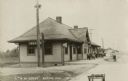
| Description: | Photographic postcard of the Chicago and North Western Depot. A group of children are in front of the depot near a cart, and two men work nearby. |
| Date: | |
|---|---|
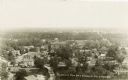
| Description: | Photographic postcard of the cities of Adams and Friendship. Elevated view of the downtown area, including tree-lined streets, city businesses and homes. |
| Date: | |
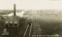
|---|---|
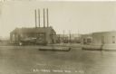
| Description: | Photographic postcard of the railroad yards. Elevated view of railroad tracks and switch-yard, with steam rising behind a brick building on the left. Railr... |
| Date: | |
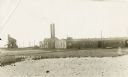
|---|---|
| Description: | Photographic postcard of railroad yards. View of railroad tracks and buildings in the distance. A coal tipple is visible in the far left background. |
| Date: | |
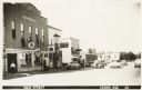
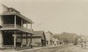
|---|---|
| Description: | Photographic postcard of Main Street. Businesses line the street, including the Adams Auto Company Dodge-Plymouth, McBride Equipment Company, and McCormick... |
| Date: | |
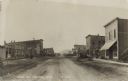
|---|---|
| Description: | Photographic postcard of Main Street. People, automobiles, and horse-drawn vehicles line the dirt-covered street and sidewalks. A Gold Medal Flour billboar... |
| Date: | |
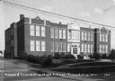
|---|---|
| Description: | View from across road of the Adams and Friendship High School on Main Street. |
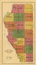
| Date: | 1916 |
|---|---|
| Description: | This early 20th century map of Adams County, Wisconsin, shows the township and range grid, towns, sections, cities and villages, roads, railroads, lakes an... |
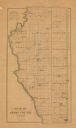
| Date: | 1900 |
|---|---|
| Description: | This map of Adams County, Wisconsin, from E.B. Foote's Plat book of Adams County, Wisconsin, 1900, shows the township and range grid, towns, sections, citi... |

| Date: | 01 01 1856 |
|---|---|
| Description: | This map is mounted on cloth and shows lots, as well as location of the public square and college. Streets are labeled as is the Wisconsin River. |

| Date: | 1855 |
|---|---|
| Description: | This map is ink, pencil, and color on paper and shows property owners, a cemetery, farms, hotels, roads, a dike and on the back are additional notes. Notes... |
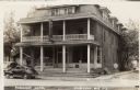
| Date: | |
|---|---|
| Description: | View across street towards the Friendship Hotel, including a tavern and cafe. Automobiles are parked in front. There are Coca-Cola signs under the front wi... |
| Date: | |
|---|---|
| Description: | View down north Main Street. The Hotel Wrchota is on the left. Horse-drawn vehicles and automobiles are further down the street. A tree-covered hill is in ... |

| Date: | |
|---|---|
| Description: | Elevated view of Friendship, with houses and commercial buildings. |

| Date: | 1908 |
|---|---|
| Description: | View of Main Street in Friendship. The J.Hill & Son General Store is on the right, with two women at the entrance. Horse-drawn vehicles are in the street. |
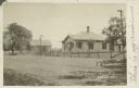
| Date: | 1910 |
|---|---|
| Description: | Text on front reads: "Residence, Dist. White Creek, Wis." Handwritten on front: "This is my cousin's house." A home with oblong-shaped openings on the porc... |
If you didn't find the material you searched for, our Library Reference Staff can help.
Call our reference desk at 608-264-6535 or email us at: