 Filter: Categories of Wisconsin Historical Images
Filter: Community of Wauwatosa
Filter: Subject of human settlements
Filter: Subject of transportation
Filter: Categories of Wisconsin Historical Images
Filter: Community of Wauwatosa
Filter: Subject of human settlements
Filter: Subject of transportation

| Date: | 1892 |
|---|---|
| Description: | Color bird's-eye map of Wauwatosa, looking east toward Milwaukee and Lake Michigan. Predominantly green with cream colored roadways, with six land plots ow... |
| Date: | 10 30 1944 |
|---|---|
| Description: | View across railroads tracks towards the Chicago, Milwaukee & St. Paul Railroad station. A number of children and adults are standing around the station. S... |

| Date: | 1947 |
|---|---|
| Description: | Center of an elevated panoramic view of a full parking lot, with the grandstand in the background. |
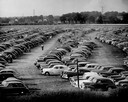
| Date: | 1947 |
|---|---|
| Description: | Right side of an elevated panoramic view of a full parking lot with houses and electrical towers in the background. |
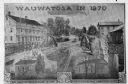
| Date: | 1870 |
|---|---|
| Description: | An advertisement featuring Wauwatosa, showing the First Baptist Church, on the left, built in 1854 and the First Congregational Church, on the right built ... |
| Date: | 1917 |
|---|---|
| Description: | The intersection of Green Bay and Cedarburg roads taken for Wisconsin Highway Department. |
| Date: | 1915 |
|---|---|
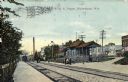
| Description: | View down railroad tracks towards the Chicago, Milwaukee and St. Paul railroad depot. Caption reads: "C.M. & St. P. Depot, Wauwatosa, Wis." |
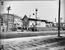
| Date: | 10 30 1944 |
|---|---|
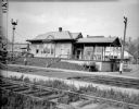
| Description: | The Chicago, Milwaukee and St. Paul railway depot. A number of pedestrians are waiting for the train. |
| Date: | 1917 |
|---|---|
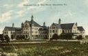
| Description: | The Milwaukee County Alms House. Caption reads: "Milwaukee County Alms House, Wauwatosa, Wis." |
| Date: | 1935 |
|---|---|
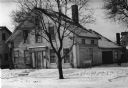
| Description: | The Lowell Damon house, east elevation or front. Snow is on the ground. |
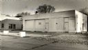
| Date: | 03 10 1981 |
|---|---|
| Description: | Exterior view of a boarded-up Amoco gas station at 6731 W. North Avenue. |

| Date: | 1947 |
|---|---|
| Description: | This map of Wauwatosa shows 10 zoning class types of land including residential, manufacturing, and business. The map also shows government buildings, some... |

| Date: | 1939 |
|---|---|
| Description: | This is a zoning map of Wauwatosa with a key of districts including agricultural, resident, business, commercial, and industrial. The map features labeled ... |

| Date: | 08 24 1908 |
|---|---|
| Description: | Text on front reads: "Lefebre [sic] Bros. Co.'s Store. Wauwatosa, Wis." A two story, brick building with a parapet and large display windows with transoms ... |
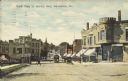
| Date: | 05 30 1911 |
|---|---|
| Description: | Text on front reads: "North Main St. looking West, Wauwatosa, Wis." Streetcars on an unpaved street with horse-drawn vehicles and pedestrians. The street i... |

| Date: | 03 25 1937 |
|---|---|
| Description: | Text on front reads: "New County General Hospital. Milwaukee County Institutions. Wauwatosa, Wis." A multistory, Neoclassical, cream brick hospital built i... |

| Date: | 07 22 1908 |
|---|---|
| Description: | Text on front reads: "Superintendent's Residence from the Lake, Milwaukee Asylum for the Chronic Insane, Wauwatosa, Wis." A three-story house with a porch... |

| Date: | 07 01 1913 |
|---|---|
| Description: | Text on front reads: "Milwaukee Asylum for Chronic Insane, Wauwatosa, Wis." Three multistory buildings with towers. A pond, trees, lawn, sidewalks and a br... |
If you didn't find the material you searched for, our Library Reference Staff can help.
Call our reference desk at 608-264-6535 or email us at: