 Filter: Categories of Wisconsin Historical Images
Filter: Community of Wausau
Filter: Year of 1900-1999
Filter: Type of Map or Atlas
Filter: Categories of Wisconsin Historical Images
Filter: Community of Wausau
Filter: Year of 1900-1999
Filter: Type of Map or Atlas

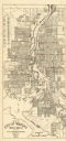
| Date: | 1932 |
|---|---|
| Description: | This map of Wausau shows lots and landownership, buildings, roads, railroads, parks, city wards, and the Wisconsin River. The map features an inset map sho... |
| Date: | 1955 |
|---|---|
| Description: | This map of Wausau distributed by the Wausau Chamber of Commerce was originally published in July of 1940 and shows the Wisconsin River. The map includes a... |
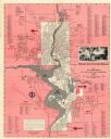
| Date: | 1954 |
|---|---|
| Description: | This map of Wausau is pink, red, gray, and white. The map includes indexes of streets, industries, and community buildings and features a photograph of the... |
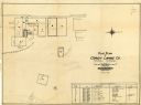
| Date: | 1928 |
|---|---|
| Description: | This plat map of Wausau is oriented with north to the right and is dated "April, 1928." The map features a building description chart with an index and inc... |

| Date: | 1915 |
|---|---|
| Description: | This map is mounted on cloth and shows lots and landownership, selected buildings, roads, railroads, parks, cemeteries, city wards, and includes advertisem... |

| Date: | 1987 |
|---|---|
| Description: | This pictorial map shows roads, bridges, local businesses with phone numbers, and public buildings. Relief is shown pictorially. Also included is a calen... |
If you didn't find the material you searched for, our Library Reference Staff can help.
Call our reference desk at 608-264-6535 or email us at: