 Filter: Categories of Wisconsin Historical Images
Filter: Community of Wausau
Filter: Subject of cities and towns
Filter: Categories of Wisconsin Historical Images
Filter: Community of Wausau
Filter: Subject of cities and towns

| Date: | |
|---|---|
| Description: | View toward the Wausau High School facade, with an stone arched entrance and central stone bay windows above. The flag pole sits on top of the tower. Capti... |

| Date: | |
|---|---|
| Description: | View across intersection toward the First National Bank building on the street corner. The Wausau Business College occupies the third floor, while J.W. Man... |
| Date: | |
|---|---|
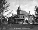
| Description: | View across lawn toward the facade and side of the Marathon County Jail. A porch wraps around one corner of the first floor, below a round turret that exte... |
| Date: | |
|---|---|
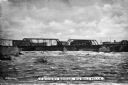
| Description: | The Chicago and Northwestern Railway Bridge spans Big Bull Falls. Multiple industrial buildings are visible in the background. |

| Date: | |
|---|---|
| Description: | A view of the Marathon County Agricultural School facade. Poured concrete pillars and an arched window surround the entrance. |

| Date: | 1904 |
|---|---|
| Description: | View of First M.E. Church, partially obscured by trees. The church has two entrances along the frontside, one of which is part of the bell tower. |
| Date: | |
|---|---|
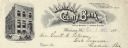
| Description: | Letterhead of the Marathon County Bank, of Wausau, Wisconsin, organized in 1875, with clouds and rays around the name of the bank. Features a three-quarter... |
| Date: | 1979 |
|---|---|
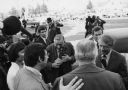
| Description: | Congressman David Obey introduces a local resident (back to camera), to President Jimmy Carter. Many photographers stand around the edge of the group and a... |
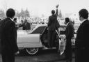
| Date: | 1979 |
|---|---|
| Description: | President Jimmy Carter stands in the open rear passenger door of a car to wave to a crowd of spectators during a visit to Congressman David R. Obey's homet... |
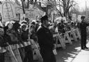
| Date: | 1979 |
|---|---|
| Description: | A group of pro-life demonstrators holding protest signs assembled to greet President Jimmy Carter during a visit to Wausau. The group is confined behind ba... |
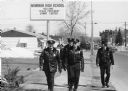
| Date: | 1979 |
|---|---|
| Description: | President Jimmy Carter's visit meant extra duty for the local police force. An elevated sign in the background reads "Newman High School, Welcome, Peace Pr... |
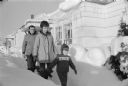
| Date: | 01 1969 |
|---|---|
| Description: | The Obey family walking in the snow at their house located at 515 N. 9th Avenue in Wausau; a casual portrait taken for David Obey's first campaign for Cong... |

| Date: | 04 1999 |
|---|---|
| Description: | Vice President Al Gore holds an unidentified child for a photograph at the Wausau Airport. Gore was in town to speak to the Better Way Club. Wisconsin Con... |
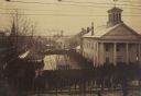
| Date: | 12 18 1890 |
|---|---|
| Description: | Elevated view looking down at homestead applicants waiting in line for 2-3 days in winter cold before a window in the Marathon County Court House, Dec. 18-... |
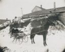
| Date: | 1906 |
|---|---|
| Description: | Winter scene with a man and woman driving in a horse-drawn "cutter" in the snow. They have a fur blanket over their laps. Behind them is a building, perhap... |

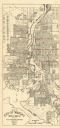
| Date: | 1932 |
|---|---|
| Description: | This map of Wausau shows lots and landownership, buildings, roads, railroads, parks, city wards, and the Wisconsin River. The map features an inset map sho... |
| Date: | 1955 |
|---|---|
| Description: | This map of Wausau distributed by the Wausau Chamber of Commerce was originally published in July of 1940 and shows the Wisconsin River. The map includes a... |
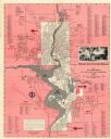
| Date: | 1954 |
|---|---|
| Description: | This map of Wausau is pink, red, gray, and white. The map includes indexes of streets, industries, and community buildings and features a photograph of the... |
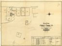
| Date: | 1928 |
|---|---|
| Description: | This plat map of Wausau is oriented with north to the right and is dated "April, 1928." The map features a building description chart with an index and inc... |
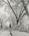
| Date: | 1963 |
|---|---|
| Description: | Winter scene with snow-covered trees after a storm in Gooding Park. |
If you didn't find the material you searched for, our Library Reference Staff can help.
Call our reference desk at 608-264-6535 or email us at: