Filter: Categories of Wisconsin Historical Images
Filter: Community of Watertown
Filter: Subject of rivers
Filter: Categories of Wisconsin Historical Images
Filter: Community of Watertown
Filter: Subject of rivers

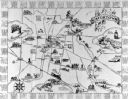
| Date: | 1885 |
|---|---|
| Description: | Bird's-eye view of Watertown with indexed points of interest. |

| Date: | 1867 |
|---|---|
| Description: | Bird's-eye map of Watertown on the Rock River, "drawn from nature." |
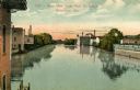
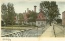
| Date: | 1910 |
|---|---|
| Description: | View from bridge with industrial buildings on both sides. Caption reads: "River view from Main St. Bridge, Watertown, Wis." |
| Date: | |
|---|---|
| Description: | A view of the river passing through Watertown looking north from the Milwaukee Street bridge. |
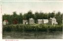
| Date: | 1842 |
|---|---|
| Description: | View across the river towards several residences on the opposite shoreline. Caption reads: "Watertown in 1842." |
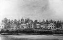
| Date: | 1841 |
|---|---|
| Description: | View across the river towards several residences on the opposite shoreline. |

| Date: | 1860 |
|---|---|
| Description: | View of the Rock River with a train on a railroad bridge in the foreground, and the town in the distance. Pedestrians are walking along a path on the left ... |
| Date: | 1870 |
|---|---|
| Description: | View across water towards the Habheger's Bowling Park at the North Fourth Street bridge. A group of people are standing on the bridge. |
| Date: | 1900 |
|---|---|
| Description: | View from bridge towards Hartig's Brewery on the left. Caption reads: "Greetings from Watertown, Wis." |
| Date: | 1890 |
|---|---|
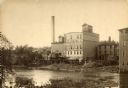
| Description: | View across water towards the Empire Mill. Alongside the building are railroad cars at a loading dock. The signs on the mill read: "Globe", "Globe's Empire... |

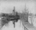
| Date: | 1910 |
|---|---|
| Description: | View of the dam across the Rock River near the Empire Mills. A man holding a fishing rod is standing in the foreground on the left. |

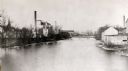
| Date: | 1915 |
|---|---|
| Description: | A dam stretching acrossed the Rock River near the Empire mills, later the Globe mills. |

| Date: | 1915 |
|---|---|
| Description: | View across water towards the railroad bridge on the Chicago, Milwaukee, & St. Paul Railway. |
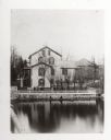
| Date: | 04 1926 |
|---|---|
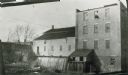
| Description: | Old stone mill, with a smaller wooden addition on the left. Water is passing through the flume. |

| Date: | |
|---|---|
| Description: | View of the Rock River. Two men stand before a dam and, beyond them, a woman stands on a bridge. Downtown buildings are visible in the background. |

| Date: | |
|---|---|
| Description: | View of Rock River from Fourth Street. Trees line the banks of the river, and a smokestack is in silhouette behind trees in the distance. |

| Date: | |
|---|---|
| Description: | View of Rock River from Main Street Bridge. Hartig Brewery, opened in 1884, is along the right shoreline. |

| Date: | |
|---|---|
| Description: | View of Prochazka's picnic place on Rock River. The view features a small boat docked on the left near trees which crowd the shoreline. Caption reads: "Pro... |
If you didn't find the material you searched for, our Library Reference Staff can help.
Call our reference desk at 608-264-6535 or email us at: