 Filter: Categories of Wisconsin Historical Images
Filter: Community of Washburn
Filter: Year of 1900-1999
Filter: Year of 1910-1919
Filter: Categories of Wisconsin Historical Images
Filter: Community of Washburn
Filter: Year of 1900-1999
Filter: Year of 1910-1919

| Date: | 1910 |
|---|---|
| Description: | Bird's-eye view looking east, with Washburn Harbor at center and Chequamegon Bay in Lake Superior covering most of the upper image. Streets with buildings... |
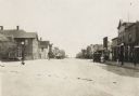
| Date: | 1916 |
|---|---|
| Description: | View looking down the center of road, with storefronts and dwellings on both sides. Automobiles and horse-drawn vehicles are parked at various points along... |

| Date: | 1918 |
|---|---|
| Description: | Manuscript map of the Chequamegon Bay area on Lake Superior drawn by Warren W. Witmer and illustrated with sketches by Mary L. Wright Witmer in ink and wat... |

| Date: | 09 1918 |
|---|---|
| Description: | An insurance map of Washburn, with an index and a key. Includes a small inset map of the State of Wisconsin that shows "Location of this town as above unde... |
If you didn't find the material you searched for, our Library Reference Staff can help.
Call our reference desk at 608-264-6535 or email us at: