 Filter: Categories of Wisconsin Historical Images
Filter: Community of Washburn
Filter: Year of 1900-1999
Filter: Subject of transportation
Filter: Categories of Wisconsin Historical Images
Filter: Community of Washburn
Filter: Year of 1900-1999
Filter: Subject of transportation

| Date: | 1910 |
|---|---|
| Description: | Bird's-eye view looking east, with Washburn Harbor at center and Chequamegon Bay in Lake Superior covering most of the upper image. Streets with buildings... |
| Date: | 1904 |
|---|---|
| Description: | View across water towards Brower Park near Houghton Point. |
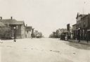
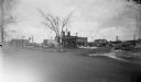
| Date: | 1916 |
|---|---|
| Description: | View looking down the center of road, with storefronts and dwellings on both sides. Automobiles and horse-drawn vehicles are parked at various points along... |
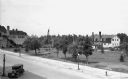
| Date: | 1932 |
|---|---|
| Description: | Elevated view of one automobile parked on Main Street near a park (the Legion Memorial Park), trees, an American flag, street lights, and various buildings... |
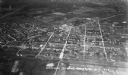
| Date: | 1935 |
|---|---|
| Description: | Aerial view, taken from an airplane, overlooking the streets, houses, stores, trees and railroad cars. |
| Date: | 1938 |
|---|---|
| Description: | View across road of the Route 66 service station. Automobiles and a Phillips 66 Chequamegon Oil Co. truck are in the parking lot. Signs around the Route 66... |
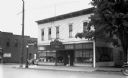
| Date: | 1936 |
|---|---|
| Description: | View across street of a wooden corner building with large plate glass windows and a sign advertising Meyer's Cafe. An advertisement is painted on the side ... |
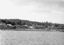
| Date: | 1942 |
|---|---|
| Description: | View from Lake Superior looking at the shoreline of Washburn. Houses, buildings, people, cars and trees are visible on shore. |
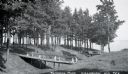
| Date: | 1932 |
|---|---|
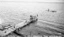
| Description: | View of two wooden foot bridges in Memorial Park. In the background are the waters of Chequamegon Bay in Lake Superior. Picnic tables are among the trees. ... |

| Date: | 1932 |
|---|---|
| Description: | Elevated view of one automobile parked on Main Street. The Legion Memorial Park is across the street. There is a hospital building in the background. Trees... |
| Date: | 1935 |
|---|---|
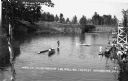
| Description: | Boys and girls wearing bathing suits standing, swimming, or diving off of a large wooden dock into Chequamegon Bay, Lake Superior on the beach at Memorial ... |
| Date: | 1936 |
|---|---|
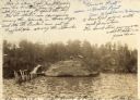
| Description: | View of the World's Championship Log-Rolling Contest, Brownstone Bowl. There are two rowboats in the water. Two men stand on a rolling log in the middle of... |

| Date: | 1932 |
|---|---|
| Description: | View of one man standing and rolling on a large ball in the water. He is holding a stick in his left hand. In the background on the left is a man in a wood... |
| Date: | 1935 |
|---|---|
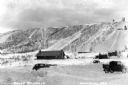
| Description: | View of Mount Valhalla during the winter near Washburn. There is a building and a few automobiles parked at the bottom of a large hill covered in snow. The... |
| Date: | 1935 |
|---|---|
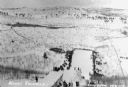
| Description: | View from the top of a ski hill jump on Mount Valhalla near Washburn. Crowds of people line the edges of the ski jump area at the bottom of the hill. |
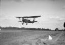
| Date: | 1932 |
|---|---|
| Description: | View of a man flying an airplane low over the airfield. He is wearing goggles and waving at the photogarpher. In the background is a barn and trees. |
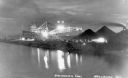
| Date: | 1936 |
|---|---|
| Description: | Unloading coal from a large ship in Lake Superior onto land near Washburn. There is a large conveyor that has lights glowing in the dark sky. A large pile ... |

| Date: | 1918 |
|---|---|
| Description: | Manuscript map of the Chequamegon Bay area on Lake Superior drawn by Warren W. Witmer and illustrated with sketches by Mary L. Wright Witmer in ink and wat... |
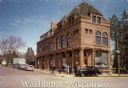
| Date: | 1990 |
|---|---|
| Description: | Text on front reads: "Washburn, Wisconsin." On reverse: "Washburn Historical Museum and Cultural Center. National Register of Historical Places. Washburn, ... |

| Date: | 09 1918 |
|---|---|
| Description: | An insurance map of Washburn, with an index and a key. Includes a small inset map of the State of Wisconsin that shows "Location of this town as above unde... |
If you didn't find the material you searched for, our Library Reference Staff can help.
Call our reference desk at 608-264-6535 or email us at: