 Filter: Categories of Wisconsin Historical Images
Filter: Community of Washburn
Filter: Subject of intellectual life
Filter: Categories of Wisconsin Historical Images
Filter: Community of Washburn
Filter: Subject of intellectual life

| Date: | 1886 |
|---|---|
| Description: | Bird's-eye map of Washburn on Lake Superior. There is an inset of Washburn, Chequamagon and the Apostle Islands. |

| Date: | 1896 |
|---|---|
| Description: | Bird's-eye view of Washburn, with twenty vignettes around side, water in foreground with docks and lumber corral. Thirty-three locations identified in key ... |

| Date: | 1910 |
|---|---|
| Description: | Bird's-eye view looking east, with Washburn Harbor at center and Chequamegon Bay in Lake Superior covering most of the upper image. Streets with buildings... |
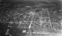
| Date: | 1935 |
|---|---|
| Description: | Aerial view, taken from an airplane, overlooking the streets, houses, stores, trees and railroad cars. |

| Date: | |
|---|---|
| Description: | Exterior of the menu for Paul's Cafe, with a bird's-eye view map of "Washburn's Natural Deep Water Land Locked Harbor," Chequamegon Bay, and the Apostle Is... |
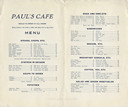
| Date: | |
|---|---|
| Description: | Interior of the Paul's Cafe menu, with "Meals to order at all hours." |
If you didn't find the material you searched for, our Library Reference Staff can help.
Call our reference desk at 608-264-6535 or email us at: