 Filter: Categories of Wisconsin Historical Images
Filter: Community of Trempealeau
Filter: Year of 1900-1999
Filter: Categories of Wisconsin Historical Images
Filter: Community of Trempealeau
Filter: Year of 1900-1999

| Date: | 1906 |
|---|---|
| Description: | Group of people stand on pier near the Diamond Jo line steamboat Quincy, sunk in 1906. It was raised and renamed the J.S. There are men on th... |
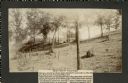
| Date: | 1905 |
|---|---|
| Description: | Two of a series of three large platform mounds on the top of a high hill, overlooking the Mississippi and Black River valleys. Two young children are seate... |
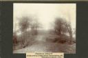
| Date: | 1905 |
|---|---|
| Description: | View across top of platform mound on the crest of a high hill. Trees are on the left and right. In the background below is the Mississippi River. |
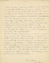
| Date: | 11 04 1921 |
|---|---|
| Description: | The last, signed page of an 11-page manuscript titled "The Platforms at Trempeleau." |
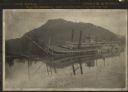
| Date: | 1906 |
|---|---|
| Description: | View across water towards the steamer Quincy, of the Diamond Jo Line, partially sunken into the Mississippi River and listing to port near the shore... |

| Date: | 1920 |
|---|---|
| Description: | This blue print map shows landownership between 1913 and 1916, topography, railroads, and roads. The map covers the vicinity of Perrot State Park. |
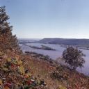
| Date: | 1972 |
|---|---|
| Description: | Elevated view looking south towards the Mississippi River from Brady's Bluff in Perrot State Park. |
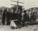
| Date: | 09 06 1926 |
|---|---|
| Description: | Group portrait of attendees at a ceremony to place a marker on the former site of the French post of Nicolas Perrot. From left to right are Dr. Eben D. Pie... |
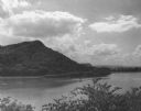
| Date: | 1952 |
|---|---|
| Description: | View of Perrot State Park from the opposite shore of the Mississippi river. |

| Date: | 1961 |
|---|---|
| Description: | People ice fishing on the frozen Mississippi River. Hills can be seen on the shoreline in the background. |
| Date: | 1936 |
|---|---|
| Description: | Text on front reads: "Trempealeau Wis. on the Great River Road overlooking Lock & Dam No. 6 on the Upper Mississippi." On reverse: "Lock & Dam No. 6, one o... |

| Date: | 1950 |
|---|---|
| Description: | Text on front reads: "Main Street - Trempealeau, Wisconsin." On reverse: "On the Grand Old Mississippi and the Great River Road near Perrot State Park and ... |

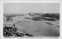
| Date: | 1920 |
|---|---|
| Description: | Text on front reads: "Trempealeau, Wis., on-the-Mississippi." Aerial view of the town on the Mississippi River. |

| Date: | 09 04 1913 |
|---|---|
| Description: | Text on front reads: "'Castle Rock,' 2nd Peak, Trempealeau, Wis., on-the-Mississippi." Elevated view towards a rock formation on the Mississippi River. Isl... |
If you didn't find the material you searched for, our Library Reference Staff can help.
Call our reference desk at 608-264-6535 or email us at:
