Filter: Categories of Wisconsin Historical Images
Filter: Community of Trempealeau
Filter: Year of 1900-1999
Filter: Subject of transportation
Filter: Categories of Wisconsin Historical Images
Filter: Community of Trempealeau
Filter: Year of 1900-1999
Filter: Subject of transportation

| Date: | 1906 |
|---|---|
| Description: | Bow of the sidewheel packet, "Quincy," sunk in 1906. People are standing on temporary pier beside her. Later raised and renamed the "J.S." |
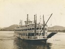
| Date: | 1901 |
|---|---|
| Description: | The sternwheel excursion, J.S., near Trempealeau, taken between 1901 and 1910. |
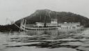
| Date: | 1906 |
|---|---|
| Description: | Side view of the sidewheel packet, Quincy, sinking in 1906. Only her two upper decks are above water. Trempealeau Mountain is in the background. Lat... |
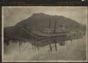
| Date: | 1906 |
|---|---|
| Description: | Sidewheel packet Quincy, sinking. Only her two upper decks are above water. Trempealeau Mountain is in the background. Later renamed the J.S. |
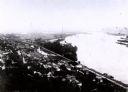
| Date: | 1907 |
|---|---|
| Description: | Elevated view from first peak of Trempealeau, Wisconsin. |
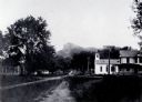
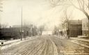
| Date: | 1907 |
|---|---|
| Description: | Fourth street in Trempealeau, Wisconsin. |

| Date: | 1931 |
|---|---|
| Description: | Drawing of the Melchoir House, which was a popular hostelry and brewery operated by Jacob Melchoir. It later became an Indian boarding house. |

| Date: | 1925 |
|---|---|
| Description: | View from road of a two-story brick structure identified as the Melchior Hotel. See also image 67069. |

| Date: | 1906 |
|---|---|
| Description: | Group of people stand on pier near the Diamond Jo line steamboat Quincy, sunk in 1906. It was raised and renamed the J.S. There are men on th... |
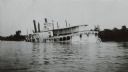
| Date: | 1906 |
|---|---|
| Description: | View across water towards the steamer Quincy, of the Diamond Jo Line, partially sunken into the Mississippi River and listing to port near the shore... |

| Date: | 1920 |
|---|---|
| Description: | This blue print map shows landownership between 1913 and 1916, topography, railroads, and roads. The map covers the vicinity of Perrot State Park. |
| Date: | 1936 |
|---|---|
| Description: | Text on front reads: "Trempealeau Wis. on the Great River Road overlooking Lock & Dam No. 6 on the Upper Mississippi." On reverse: "Lock & Dam No. 6, one o... |

| Date: | 1950 |
|---|---|
| Description: | Text on front reads: "Main Street - Trempealeau, Wisconsin." On reverse: "On the Grand Old Mississippi and the Great River Road near Perrot State Park and ... |

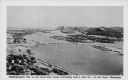
| Date: | 1920 |
|---|---|
| Description: | Text on front reads: "Trempealeau, Wis., on-the-Mississippi." Aerial view of the town on the Mississippi River. |
If you didn't find the material you searched for, our Library Reference Staff can help.
Call our reference desk at 608-264-6535 or email us at: