 Filter: Categories of Wisconsin Historical Images
Filter: Community of Superior
Filter: Year of 1900-1999
Filter: Categories of Wisconsin Historical Images
Filter: Community of Superior
Filter: Year of 1900-1999

| Date: | 1932 |
|---|---|
| Description: | This map of Superior shows many points of interests including camping, fair grounds, docks, tourist attractions, lakes, roads, and waterways. |

| Date: | 1922 |
|---|---|
| Description: | Semi-panoramic view of rapids, water pouring near the dam of the Great Northern Paper Company. |
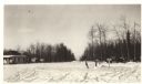
| Date: | 01 31 1936 |
|---|---|
| Description: | View across snow towards a concession building on the left and a parked truck on the right. Caption on back reads: "Concession building is at the left. The... |
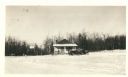
| Date: | 01 31 1936 |
|---|---|
| Description: | The description on the back reads: "The custodian building in Pattison Park which will not conform with the Combination building 200 feet away if the latte... |
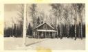
| Date: | 01 31 1936 |
|---|---|
| Description: | View across snow towards concession building with an automobile parked in front near the porch. There is a Hamm's Beer sign hanging off the roof. Annotatio... |

| Date: | 1972 |
|---|---|
| Description: | Before or after a Minnesota vs. Wisconsin Democrats softball game. Congressman David Obey holds up a concept rendering the future Richard I. Bong Memorial ... |
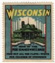
| Date: | 1928 |
|---|---|
| Description: | Stamp for Wisconsin created during or after President Calvin Coolidge's 1928 summer visit to Wisconsin. President Coolidge spent the summer fishing on the ... |

| Date: | 09 1929 |
|---|---|
| Description: | Harvested bundles of oats in a field on the Dean farm. |

| Date: | 1901 |
|---|---|
| Description: | This map shows streets, industrial buildings, a portion of Lake Superior and other lakes, bays, and rivers in portions of Duluth and Superior. Relief is sh... |

| Date: | 1914 |
|---|---|
| Description: | This map shows streets, industrial buildings, a portion of Lake Superior and other lakes, bays, and rivers in portions of Duluth and Superior. Relief is sh... |

| Date: | 1916 |
|---|---|
| Description: | This map is mounted on cloth and shows lots and roads. An inset map is included that shows towns, lakes, rivers, and railroads within portions of the Dakot... |

| Date: | 1919 |
|---|---|
| Description: | This map shows details of the harbor, proposed route and bridge changes, railroads, streets, selected buildings, a portion of Lake Superior and other lakes... |

| Date: | 1940 |
|---|---|
| Description: | This ward map shows streets, the Nemadji River, and addition and division boundaries. Also included is a list of members of the Douglas County Board town, ... |

| Date: | 1908 |
|---|---|
| Description: | This map shows streets, industrial buildings, a portion of Lake Superior and other lakes, bays, and rivers in portions of Duluth and Superior. Relief is sh... |

| Date: | 1900 |
|---|---|
| Description: | This map shows streets, railroads, dock and harbor lines, and parks. The map includes population tables for 1880, 1890, 1900. |
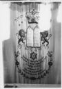
| Date: | 02 1977 |
|---|---|
| Description: | Hebrew Brotherhood Synagogue torah. |
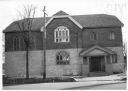
| Date: | 02 1977 |
|---|---|
| Description: | Exterior view from street of the Hebrew Brotherhood Synagogue. |
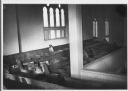
| Date: | 02 1977 |
|---|---|
| Description: | A view of the women's balcony in the Hebrew Brotherhood Synagogue. |
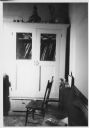
| Date: | 02 1977 |
|---|---|
| Description: | A side room in the synagogue, with a bench and a chair in the foreground, and a cabinet with glass windows against the wall in the background. |
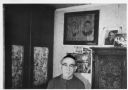
| Date: | 02 1977 |
|---|---|
| Description: | Rabbi Alex Hyatt stands in front of framed photographs displayed on the wall. |
If you didn't find the material you searched for, our Library Reference Staff can help.
Call our reference desk at 608-264-6535 or email us at: