 Filter: Categories of Wisconsin Historical Images
Filter: Community of Superior
Filter: Year of 1900-1999
Filter: Categories of Wisconsin Historical Images
Filter: Community of Superior
Filter: Year of 1900-1999
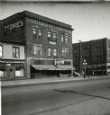
| Date: | 08 1947 |
|---|---|
| Description: | Exterior view of the Tyomies Publishing Company building. The 6th Street Cafe is next door on the left. |
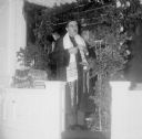
| Date: | 1960 |
|---|---|
| Description: | Rabbi Mayer Relles after performing a wedding. |
| Date: | 1961 |
|---|---|
| Description: | Ida Banon Relles and son George at George's Bar Mitzvah, Superior Hebrew Congregation. |

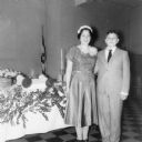
| Date: | 1962 |
|---|---|
| Description: | Relles family portrait, from left: George, Ida Banon Relles, David, Rabbi Mayer Relles, Nathan. |

| Date: | 1964 |
|---|---|
| Description: | Rabbi Mayer Relles after performing a wedding at Superior Hebrew Congregation. |
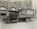
| Date: | 1919 |
|---|---|
| Description: | A man sits in an International model "G" truck that has wood furniture and crates filling the bed. The building behind has signs advertising for a laundry. |
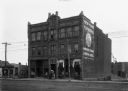
| Date: | 1900 |
|---|---|
| Description: | The Russell Block, 1606-1608 Tower Avenue. The 1899 City Directory makes the first mention of New York Furriers, Simmons and Malik, proprietors. New York F... |
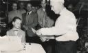
| Date: | 1957 |
|---|---|
| Description: | Clough Gates, publisher of the "Superior Telegram," cutting a cake to celebrate his 80th birthday. Max Lavine stands in the middle background, and watching... |

| Date: | 11 1952 |
|---|---|
| Description: | John Lavine (left), Nancy Jane Nelson, Virginia Rafshol, and Gary Berger indicate their support for the presidential candidacy of Dwight D. Eisenhower. As ... |
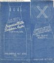
| Date: | 02 14 1935 |
|---|---|
| Description: | Blueprint submitted to the State of Wisconsin for trademark registration from the Superior Milk Dealers Association. Features a drawing of the bottle and b... |
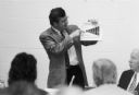
| Date: | 06 1992 |
|---|---|
| Description: | During the 1990s Congressman David R. Obey, a leading proponent of health care reform, held numerous forums on the subject in his northern Wisconsin distri... |

| Date: | 1911 |
|---|---|
| Description: | This map, taken from the 1911 Map of Wisconsin showing geology and roads by Hotchkiss and Thwaites, shows the northwest portion of Douglas County, Wisconsi... |

| Date: | 1938 |
|---|---|
| Description: | This 1938 tourist map of Douglas County, Wisconsin, identifies game refuges, fishing locations, and other outdoor recreation opportunities in the county. A... |

| Date: | 1907 |
|---|---|
| Description: | This map of Superior and the vicinity shows selected company properties, railroads, and roads in a portion of Douglas County. The map reads: "Copyrighted 1... |

| Date: | 1909 |
|---|---|
| Description: | This map of Duluth and Superior was issued by the Duluth Street Railway Company and shows street railway routes in the cities, as well as lakes, bays, harb... |

| Date: | 1909 |
|---|---|
| Description: | This map shows Duluth, Minnesota and Superior, Wisconsin, and portions of Saint Louis County, Minnesota and Douglas County, Wisconsin. Water depth is shown... |

| Date: | 1911 |
|---|---|
| Description: | This map of Duluth and Superior shows street car routes, railroads, ferries, some points of interest, and lighthouses. The bottom left of the map reads: "C... |

| Date: | 1925 |
|---|---|
| Description: | This map of Howard's Bay located at the Duluth Superior Harbor is a close view of Connors Point and shows a key to prevailing winds and water depth measure... |

| Date: | 1934 |
|---|---|
| Description: | This map shows industrial points of interest in Superior. The top of the map reads: "Superior, Douglas County, Wisconsin, as this Industrial Tour map indic... |

| Date: | 1951 |
|---|---|
| Description: | This map of Superior shows labeled streets, waterways, railroads, and company ownership of docks. |
If you didn't find the material you searched for, our Library Reference Staff can help.
Call our reference desk at 608-264-6535 or email us at: