 Filter: Categories of Wisconsin Historical Images
Filter: Community of Superior
Filter: Year of 1800-1899
Filter: Year of 1880-1889
Filter: Categories of Wisconsin Historical Images
Filter: Community of Superior
Filter: Year of 1800-1899
Filter: Year of 1880-1889

| Date: | 1883 |
|---|---|
| Description: | Bird's-eye map of Superior, county seat of Douglas County, on the shores of Lake Superior, with insets of points of interest. |

| Date: | 1887 |
|---|---|
| Description: | Bird's-eye view of Superior, on Lake Superior. |
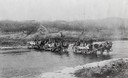
| Date: | 1880 |
|---|---|
| Description: | Crossing a river on the way to Vermillion Lake in the early 1880's, before the building of any railroads in that part of the country. The teams were part o... |

| Date: | 1885 |
|---|---|
| Description: | Illustrated view of Superior, as well as Omaha, Kansas City, St. Paul, and Winnipeg. Caption reads: "Superior - The Last Possible Great Marine City in the ... |
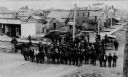
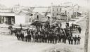
| Date: | 1889 |
|---|---|
| Description: | View of Superior, with a large group of men posting in a road in the foreground, and various buildings behind them. |
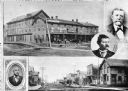
| Date: | 1885 |
|---|---|
| Description: | Collage of images featuring a view of the Nicollet House, a view down a main street, and portrait photographs of O.K. Hall, James Kane, and August Zachau. |
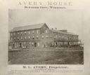
| Date: | 1880 |
|---|---|
| Description: | Exterior view of the Avery House, with groups of people gathered on its porches and balcony. |

| Date: | 1887 |
|---|---|
| Description: | This map shows lot and block numbers, established dock lines, docks, slips, railroads, and streets of West Superior in 1887. |

| Date: | 1889 |
|---|---|
| Description: | This map shows lot and block numbers, established dock lines, docks, slips, railroads, and streets of West Superior in 1889. |
| Date: | 1889 |
|---|---|
| Description: | Elevated view of group gathered and posed on a new street. Behind the group is a large pile of lumber, wooden sidewalks, and what appear to be newly-constr... |

| Date: | 1886 |
|---|---|
| Description: | This map shows lot and block numbers, sold lots, established dock lines, docks, slips, railroads, industrial buildings, streets, and the St. Louis Bay. |

| Date: | 07 04 1889 |
|---|---|
| Description: | Elevated view looking south along unpaved Tower Avenue of storefronts, American flags are flying from a number of the commercial buildings. |
If you didn't find the material you searched for, our Library Reference Staff can help.
Call our reference desk at 608-264-6535 or email us at: