 Filter: Categories of Wisconsin Historical Images
Filter: Community of Superior
Filter: Subject of transportation
Filter: Categories of Wisconsin Historical Images
Filter: Community of Superior
Filter: Subject of transportation
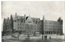
| Date: | 1891 |
|---|---|
| Description: | Exterior view of the West Superior Hotel. There are pedestrians, a street car, and people riding in horse-drawn carriages on the street in front of the hot... |
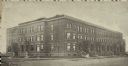
| Date: | 1890 |
|---|---|
| Description: | Exterior view from across street of Roosevelt Terrace apartments. |

| Date: | 11 1952 |
|---|---|
| Description: | John Lavine (left), Nancy Jane Nelson, Virginia Rafshol, and Gary Berger indicate their support for the presidential candidacy of Dwight D. Eisenhower. As ... |
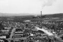
| Date: | |
|---|---|
| Description: | Elevated view of the city with a smokestack in the distance. |

| Date: | |
|---|---|
| Description: | Letterhead of the City of Superior, Wisconsin, with a three-quarter view of City Hall, printed in blue-green ink, with additional text in brown ink, by Typ... |

| Date: | 1891 |
|---|---|
| Description: | Photograph of a painting by May Conniff Frost showing the tugboat Record of the Inman Line pulling a lake schooner through rough waters into Superio... |

| Date: | 1911 |
|---|---|
| Description: | This map, taken from the 1911 Map of Wisconsin showing geology and roads by Hotchkiss and Thwaites, shows the northwest portion of Douglas County, Wisconsi... |

| Date: | 1890 |
|---|---|
| Description: | This map of Superior shows labeled streets, railroads, docks, city wards, and the state line. Relief is shown by hachures. Below the title reads: "Bedford ... |

| Date: | 1890 |
|---|---|
| Description: | This map of Superior shows city wards, bays, docks, some businesses and points of interest. Relief is shown by hachures. The back of the map features a typ... |

| Date: | 1898 |
|---|---|
| Description: | This map of Superior shows city wards, bays, docks, and some businesses and points of interest. Relief is shown by hachures. The map probably came from a C... |

| Date: | 1898 |
|---|---|
| Description: | This map of Duluth and Superior show lands that "will be for sale soon" in portions of Douglas County, Wisconsin and Saint Louis County, Minnesota. The map... |

| Date: | 1907 |
|---|---|
| Description: | This map of Superior and the vicinity shows selected company properties, railroads, and roads in a portion of Douglas County. The map reads: "Copyrighted 1... |

| Date: | 1909 |
|---|---|
| Description: | This map of Duluth and Superior was issued by the Duluth Street Railway Company and shows street railway routes in the cities, as well as lakes, bays, harb... |

| Date: | 1911 |
|---|---|
| Description: | This map of Duluth and Superior shows street car routes, railroads, ferries, some points of interest, and lighthouses. The bottom left of the map reads: "C... |

| Date: | 1934 |
|---|---|
| Description: | This map shows industrial points of interest in Superior. The top of the map reads: "Superior, Douglas County, Wisconsin, as this Industrial Tour map indic... |

| Date: | 1951 |
|---|---|
| Description: | This map of Superior shows labeled streets, waterways, railroads, and company ownership of docks. |

| Date: | 1932 |
|---|---|
| Description: | This map of Superior shows many points of interests including camping, fair grounds, docks, tourist attractions, lakes, roads, and waterways. |

| Date: | 1860 |
|---|---|
| Description: | This map of Superior is oriented with north to the upper left. Relief is shown by hachures and water depths are shown by soundings. Lake Superior and bays ... |

| Date: | 1863 |
|---|---|
| Description: | This map of Superior shows Montgomery's Addition. An inset map shows the south west end of Lake Superior where Montgomery's Addition is located. The map re... |

| Date: | 1887 |
|---|---|
| Description: | This map shows lot and block numbers, established dock lines, docks, slips, railroads, and streets of West Superior in 1887. |
If you didn't find the material you searched for, our Library Reference Staff can help.
Call our reference desk at 608-264-6535 or email us at: