Filter: Categories of Wisconsin Historical Images
Filter: Community of Superior
Filter: Subject of land use
Filter: Categories of Wisconsin Historical Images
Filter: Community of Superior
Filter: Subject of land use

| Date: | 1890 |
|---|---|
| Description: | Bird's-eye map of West Superior and Superior, with insets of Wright Farm and First Building in Superior. |
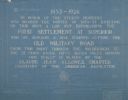
| Date: | |
|---|---|
| Description: | Blueprint of the Military Road marker design, which honors the pioneers who established the first settlement in Superior. |
| Date: | 1930 |
|---|---|
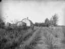
| Description: | View of the Davidson Feed Mill near the Amnicon River. |
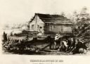
| Date: | 1855 |
|---|---|
| Description: | Chronicle newspaper office, the first building on the townsite of Superior, built in 1853 by William C. Howenstine, John T. Morgan, and August Zachau. |
| Date: | 1930 |
|---|---|
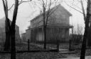
| Description: | Exterior view of the Ashton home, built in about 1853 or 1854. |
| Date: | 1890 |
|---|---|
| Description: | Letterhead for Moulton, Moran & Co. The logo shows North America and depicts Superior as the center of a hub with spokes going to Russia, to China and Japa... |
| Date: | 11 1952 |
|---|---|
| Description: | John Lavine (left), Nancy Jane Nelson, Virginia Rafshol, and Gary Berger indicate their support for the presidential candidacy of Dwight D. Eisenhower. As ... |
| Date: | 09 07 1895 |
|---|---|
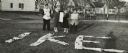
| Description: | A garden of red currant bushes, owned by Jas. S. Ritchie, are featured on his fruit farm. |

| Date: | 1934 |
|---|---|
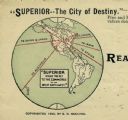
| Description: | This map shows industrial points of interest in Superior. The top of the map reads: "Superior, Douglas County, Wisconsin, as this Industrial Tour map indic... |

| Date: | 1972 |
|---|---|
| Description: | Before or after a Minnesota vs. Wisconsin Democrats softball game. Congressman David Obey holds up a concept rendering the future Richard I. Bong Memorial ... |

| Date: | 1861 |
|---|---|
| Description: | This map shows lot and block numbers, piers, streets, monuments, and township section corners. Included is a note on the width of avenues, piers, slips, al... |

| Date: | |
|---|---|
| Description: | View over parked cars towards the Superior Refinery, which did business as Murphy Oil Corporation at another time. The oil refinery was located at Stinson ... |
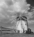
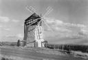
| Date: | 1950 |
|---|---|
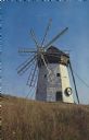
| Description: | Text on reverse reads: "On Highway 13. Scenic Old Mill. This picturesque windmill is seen along the beautiful South Shore Drive, Hiway [number struck out w... |

| Date: | 1978 |
|---|---|
| Description: | Text on reverse reads: "The Seamen's Memorial Statue, Barker's Island, Superior, WI. Facing the harbor holding a massive cable is the 10 foot tall Seamen's... |
If you didn't find the material you searched for, our Library Reference Staff can help.
Call our reference desk at 608-264-6535 or email us at: