 Filter: Categories of Wisconsin Historical Images
Filter: Community of Superior
Filter: Subject of intellectual life
Filter: Categories of Wisconsin Historical Images
Filter: Community of Superior
Filter: Subject of intellectual life

| Date: | 1883 |
|---|---|
| Description: | Bird's-eye map of Superior, county seat of Douglas County, on the shores of Lake Superior, with insets of points of interest. |

| Date: | 1890 |
|---|---|
| Description: | Bird's-eye view of Superior, Wisconsin. |

| Date: | 1913 |
|---|---|
| Description: | Bird's-eye map of Superior. "The New Steel Center." |

| Date: | 1915 |
|---|---|
| Description: | Bird's-eye view of Superior, Wisconsin, and Duluth, Minnesota on opposite shore of Lake Superior. |

| Date: | 1887 |
|---|---|
| Description: | Bird's-eye view of Superior, on Lake Superior. |

| Date: | 1890 |
|---|---|
| Description: | Bird's-eye map of West Superior and Superior, with insets of Wright Farm and First Building in Superior. |

| Date: | 1893 |
|---|---|
| Description: | Bird's-eye map of Superior. Looking from the point, with Superior Bay on left, St. Louis Bay on right, below St. Louis River. |

| Date: | 1961 |
|---|---|
| Description: | Aerial view of the Duluth-Superior bridge. |
| Date: | 1940 |
|---|---|
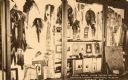
| Description: | Dipslay of Sioux Indian Relics. Caption reads: "Barry Room, Sioux Indian Relics, Douglas County Historical Museum, Superior, Wis." |
| Date: | 1855 |
|---|---|
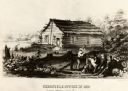
| Description: | Chronicle newspaper office, the first building on the townsite of Superior, built in 1853 by William C. Howenstine, John T. Morgan, and August Zachau. |

| Date: | 1960 |
|---|---|
| Description: | Aerial view with docks in the foreground. Caption reads: "Superior, Wisconsin." |

| Date: | 1985 |
|---|---|
| Description: | Aerial view of the Duluth-Superior Bridge, officially named in honor of Richard I. Bong, World War II's Ace of Aces, who hailed from nearby Poplar, Wiscons... |
| Date: | 08 1947 |
|---|---|
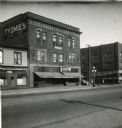
| Description: | Exterior view of the Tyomies Publishing Company building. The 6th Street Cafe is next door on the left. |
| Date: | |
|---|---|
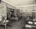
| Description: | Interior view of the Superior Public Library. Reverse of the cardboard backing reads: "Arch: Carl Wirth, 1902, Carnegie bldg., cost $50,000." In the foregr... |
| Date: | |
|---|---|
| Description: | Interior view of the Superior Public Library. One doorway frames a woman (librarian?) working at an eight-sided librarian's desk. A picture of Andrew Carne... |
| Date: | |
|---|---|
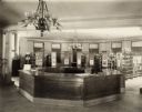
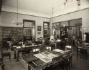
| Description: | Interior view of the Superior Public Library. In the room are reading tables and bookshelves along the wall. Several doors lead to other rooms, and there i... |
| Date: | 1890 |
|---|---|
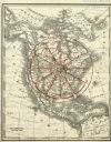
| Description: | Letterhead for Moulton, Moran & Co. The logo shows North America and depicts Superior as the center of a hub with spokes going to Russia, to China and Japa... |
| Date: | 1890 |
|---|---|
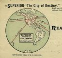
| Description: | Rand, McNally map of North America enhanced to show Superior as the center of a wheel. The image was used on the back of stationery from City Improvement C... |
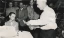
| Date: | 1957 |
|---|---|
| Description: | Clough Gates, publisher of the "Superior Telegram," cutting a cake to celebrate his 80th birthday. Max Lavine stands in the middle background, and watching... |
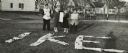
| Date: | 11 1952 |
|---|---|
| Description: | John Lavine (left), Nancy Jane Nelson, Virginia Rafshol, and Gary Berger indicate their support for the presidential candidacy of Dwight D. Eisenhower. As ... |
If you didn't find the material you searched for, our Library Reference Staff can help.
Call our reference desk at 608-264-6535 or email us at: