 Filter: Categories of Wisconsin Historical Images
Filter: Community of Sturgeon Bay
Filter: Subject of human settlements
Filter: Categories of Wisconsin Historical Images
Filter: Community of Sturgeon Bay
Filter: Subject of human settlements
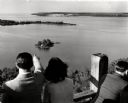
| Date: | 1945 |
|---|---|
| Description: | People on observation tower looking at Sturgeon Bay. |

| Date: | 2008 |
|---|---|
| Description: | Since the 1930s, the busy corner on Michigan Street has been the site of a succession of gas stations that have continually evolved to reflect changes in t... |

| Date: | |
|---|---|
| Description: | Exterior view of the Sturgeon Bay Public Library. Library opened in 1913 with a gift of $12,500 from Andrew Carnegie. Above the main entrance it reads: "Fr... |
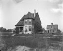
| Date: | 08 28 1898 |
|---|---|
| Description: | Exterior shot of Dankoler's house near Humbolt Park. A house and a barn-like structure are in the background. |
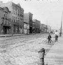
| Date: | 1900 |
|---|---|
| Description: | Syl stands holding an umbrella near an unidentified boy who is leaning on a bicycle on the edge of a cobblestone street. Storefronts are along the street o... |
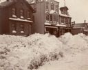
| Date: | 1900 |
|---|---|
| Description: | Winter scene of a Sturgeon Bay street. The exteriors of storefronts are piled high with banks of snow. Signage reads "O.E. Klug & Co. Hardware" and "O.E. ... |

| Date: | |
|---|---|
| Description: | Exterior view of the Sturgeon Bay Public Library, which opened in 1913 after a Carnegie Grant. Above the arched main entrance a sign reads, "Free Library." |

| Date: | |
|---|---|
| Description: | View down Main Street. Automobiles are parked along the curbs, pedestrians are on the sidewalks in front of storefronts. Hotel Swoboda can be seen at left;... |
| Date: | |
|---|---|
| Description: | Letterhead of the Horn's Pier (Door County) office of Horn & Joseph, dealers in general merchandise, including "Wood, Bark, Ties, Telegraph Poles, Posts, &... |

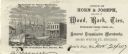
| Date: | 1899 |
|---|---|
| Description: | Map of Door County with inset photograph of Sturgeon Bay City. |
| Date: | 1908 |
|---|---|
| Description: | Postcard view of the tower. Caption reads: "Sturgeon Bay Canal Light Tower." |

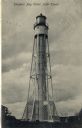
| Date: | 1943 |
|---|---|
| Description: | This map of Sturgeon Bay shows section and quarter corners, ward divisions, government building locations, roads, and railroads. The map includes a legend ... |

| Date: | 1950 |
|---|---|
| Description: | This map of Sturgeon Bay is part of the survey of the northern and northwestern lakes. The map shows lights, railroads, roads, and some public buildings. R... |

| Date: | 1941 |
|---|---|
| Description: | Elevated view of Sturgeon Bay in 1900. Sturgeon Bay Bridge spans the bay and several boats are on the water. A lighthouse sits on a small island in the bay... |
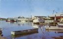
| Date: | 1958 |
|---|---|
| Description: | View from pier of Peterson's Boat Works in Sturgeon Bay. |

| Date: | 06 25 1901 |
|---|---|
| Description: | This map shows beacons, buoys, docks, quarries, streets, and buildings. The map inset shows the Harbor of refuge at entrance to Sturgeon Bay and Lake Michi... |

| Date: | 12 28 1908 |
|---|---|
| Description: | This map shows beacons, buildings, streets, and quarries. Two inset maps include: Vicinity of Sturgeon Bay, Wis. and the Harbor of refuge at entrance to St... |

| Date: | 01 06 1958 |
|---|---|
| Description: | View from jetty out towards Lake Michigan entrance to Ship Canal. A large tank, streetlamp and buildings are on the left. On the opposite jetty is a lighth... |
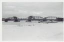
| Date: | 01 06 1958 |
|---|---|
| Description: | View from snowy shoreline of Highway Bridge, the east approach. The lake is frozen. Just beyond the shoreline a boat is moored at a landing, and an automob... |

| Date: | |
|---|---|
| Description: | Aerial view of harbors and bridge. Farm fields are on either side of the bridge. The city of Sturgeon Bay is in the distance. There are docks along the sho... |
If you didn't find the material you searched for, our Library Reference Staff can help.
Call our reference desk at 608-264-6535 or email us at: