 Filter: Categories of Wisconsin Historical Images
Filter: Community of Stevens Point
Filter: Subject of transportation
Filter: Year of 1900-1999
Filter: Categories of Wisconsin Historical Images
Filter: Community of Stevens Point
Filter: Subject of transportation
Filter: Year of 1900-1999

| Date: | 1910 |
|---|---|
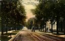
| Description: | View down center of tree-lined street. Caption reads: "Main Street, Looking West, Stevens Point, Wis." |

| Date: | 1910 |
|---|---|
| Description: | View down center of street. Caption reads: "Main Street, Looking East, Stevens Point, Wis." |
| Date: | 1900 |
|---|---|
| Description: | View down center of tree-lined street. Caption reads: "Main Street from Presbyterian Church, Stevens Point, Wis." |
| Date: | 1930 |
|---|---|
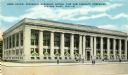
| Description: | View across street towards the building. Caption reads: "Home Office, Wisconsin Hardware Mutual Fire and Casualty Companies, Stevens Point Wis." |

| Date: | 1910 |
|---|---|
| Description: | Caption reads: "Episcopal Church, Stevens Point, Wis." |

| Date: | 1910 |
|---|---|
| Description: | View down center of street. Caption reads: "Clark Street, Looking East, Stevens Point, Wis." |

| Date: | 1905 |
|---|---|
| Description: | View down center of street. Caption reads: "Clark Street, Stevens Point, Wis." |
| Date: | 1915 |
|---|---|
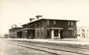
| Description: | View across railroad tracks towards the Chicago, Milwaukee, & Sault Sainte Marie Railway Depot. In the background on the right is the Star Restaurant. Capt... |
| Date: | 1905 |
|---|---|
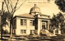
| Description: | View across street towards the library. Caption reads: "Public Library, Stevens Point, Wis." |

| Date: | 1905 |
|---|---|
| Description: | View across the street towards the library. Caption reads: "Carnegie Library, Stevens Point, Wis." |

| Date: | 1910 |
|---|---|
| Description: | View across grass towards a wagon bridge on the left crossing the Wisconsin River at Stevens Point. Caption reads: "Wagon Bridge, across Wisconsin River, S... |
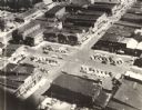
| Date: | 1955 |
|---|---|
| Description: | Aerial view of town, with commercial buildings, and cars in parking lots. |

| Date: | 1965 |
|---|---|
| Description: | Aerial view that encompasses most of the town and part of the Wisconsin River. |

| Date: | 1912 |
|---|---|
| Description: | Exterior of River Pine Sanitarium, which opened in 1906. A path surrounded by trees leads past benches to the sanitarium porch. Caption reads: "River Pine ... |

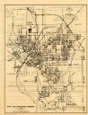
| Date: | 1910 |
|---|---|
| Description: | This map of Stevens Point shows the Wisconsin River, labeled plat additions, numbered lots, and some land ownership. An inset map in the bottom left corner... |
| Date: | 1971 |
|---|---|
| Description: | This map of Stevens Point shows labeled streets and selected points of interest: "Holiday Inn," "Westernberger's Gifts," "Ralph L. Banke MLS Realtor," "Gol... |
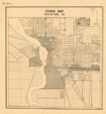
| Date: | 1920 |
|---|---|
| Description: | This map shows zoning in the city of Stevens Point. Streets are labeled and the upper right hand corner features a "Legend & Summary Of Zoning Regulations"... |

| Date: | 1986 |
|---|---|
| Description: | Pictorial map showing businesses with phone numbers, roads, railroads, and parks. Includes text titled: "History of Portage County." |

| Date: | 1923 |
|---|---|
| Description: | View of a street in downtown Stevens Point. Model T's are parked along the curbs. Children are standing near the cars on both sides of the street. |

| Date: | 1950 |
|---|---|
| Description: | This blueline print shows roads and proposed roads in parts of the Towns of Carson, Hull, Linwood, and Plover, as well as boundaries and lines demarking ex... |
If you didn't find the material you searched for, our Library Reference Staff can help.
Call our reference desk at 608-264-6535 or email us at: