 Filter: Categories of Wisconsin Historical Images
Filter: Community of Stevens Point
Filter: Subject of human settlements
Filter: Categories of Wisconsin Historical Images
Filter: Community of Stevens Point
Filter: Subject of human settlements

| Date: | |
|---|---|
| Description: | View of Saint Stanislaus Kostka Catholic Church, completed in 1918. A staircase leads to the main entrance of the brick building with a belfry. |

| Date: | |
|---|---|
| Description: | Exterior of an Episcopal Church. The view from the opposite street corner displays the stone building's belfry and main entrance. Stained glass windows in ... |
| Date: | |
|---|---|
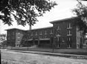
| Description: | Exterior view of Nelson Hall, a girls' dormitory built in 1915 for the State Normal School system. A path leads to the brick building's main entrance and p... |

| Date: | |
|---|---|
| Description: | Exterior of a High School. The elaborate brick building features a central entrance flanked by two small towers. |

| Date: | |
|---|---|
| Description: | Exterior of Hotel Jacobs. Stairs lead to the porch of the three-story house. A sign above windows reads, "Jacobs House." A shoe polishing station can be se... |

| Date: | |
|---|---|
| Description: | Exterior of the Hardware Mutual Insurance office building. The Wisconsin Retail Hardware Association and the Fire and Casualty Company opened the new three... |

| Date: | |
|---|---|
| Description: | Exterior of the Carnegie Public Library, built in 1903 after the receipt of a 1902 Carnegie Grant. A set of stairs leads from the sidewalk to the main entr... |

| Date: | |
|---|---|
| Description: | Exterior of Portage County Courthouse, built in 1868. Stairs lead to the main entrance of the stone building and a monument and cannon stand on the lawn. |

| Date: | |
|---|---|
| Description: | Exterior of the Consolidated Water Power and Paper Company, built in 1918. The view from across the Wisconsin River shows the company building, a dam, as w... |

| Date: | |
|---|---|
| Description: | View taken from the Paper Mill Road toward the Wisconsin River Pulp and Paper Company paper mill. On the bank in the foreground are small boats. The paper ... |

| Date: | |
|---|---|
| Description: | Exterior view of the Post Office, built in 1919. The view from across Main Street shows men standing at the main entrance of a stone building built in the ... |

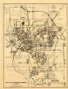
| Date: | 1910 |
|---|---|
| Description: | This map of Stevens Point shows the Wisconsin River, labeled plat additions, numbered lots, and some land ownership. An inset map in the bottom left corner... |
| Date: | 1971 |
|---|---|
| Description: | This map of Stevens Point shows labeled streets and selected points of interest: "Holiday Inn," "Westernberger's Gifts," "Ralph L. Banke MLS Realtor," "Gol... |
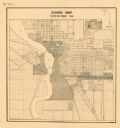
| Date: | 1920 |
|---|---|
| Description: | This map shows zoning in the city of Stevens Point. Streets are labeled and the upper right hand corner features a "Legend & Summary Of Zoning Regulations"... |
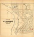
| Date: | 1852 |
|---|---|
| Description: | This map of Stevens Point shows lot numbers, land reservations for steam saw mill, and Shaurette Mills. The top right features an inset map: Sec. 31 & 32, ... |

| Date: | 1986 |
|---|---|
| Description: | Pictorial map showing businesses with phone numbers, roads, railroads, and parks. Includes text titled: "History of Portage County." |

| Date: | 1923 |
|---|---|
| Description: | View of a street in downtown Stevens Point. Model T's are parked along the curbs. Children are standing near the cars on both sides of the street. |

| Date: | 1950 |
|---|---|
| Description: | This blueline print shows roads and proposed roads in parts of the Towns of Carson, Hull, Linwood, and Plover, as well as boundaries and lines demarking ex... |

| Date: | 05 16 1994 |
|---|---|
| Description: | The front side of this map shows roads, highways, the Wisconsin River, Stevens Point Airport, and surrounding towns. A street index is included along the r... |
| Date: | 1958 |
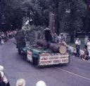
|---|---|
| Description: | Elevated view over a crowd of people watching a parade. The Wisconsin Conservation Department float is coming down the road. It features a forest with taxi... |
If you didn't find the material you searched for, our Library Reference Staff can help.
Call our reference desk at 608-264-6535 or email us at: