 Filter: Categories of Wisconsin Historical Images
Filter: Community of Stevens Point
Filter: Type of Map or Atlas
Filter: Subject of rivers
Filter: Categories of Wisconsin Historical Images
Filter: Community of Stevens Point
Filter: Type of Map or Atlas
Filter: Subject of rivers

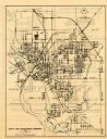
| Date: | 1891 |
|---|---|
| Description: | Bird's-eye map of Stevens Point, looking east, with an inset of the Water Works. Wisconsin River in foreground with fifty-three business locations identifi... |

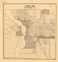
| Date: | 1910 |
|---|---|
| Description: | This map of Stevens Point shows the Wisconsin River, labeled plat additions, numbered lots, and some land ownership. An inset map in the bottom left corner... |
| Date: | 1971 |
|---|---|
| Description: | This map of Stevens Point shows labeled streets and selected points of interest: "Holiday Inn," "Westernberger's Gifts," "Ralph L. Banke MLS Realtor," "Gol... |
| Date: | 1920 |
|---|---|
| Description: | This map shows zoning in the city of Stevens Point. Streets are labeled and the upper right hand corner features a "Legend & Summary Of Zoning Regulations"... |
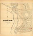
| Date: | 1852 |
|---|---|
| Description: | This map of Stevens Point shows lot numbers, land reservations for steam saw mill, and Shaurette Mills. The top right features an inset map: Sec. 31 & 32, ... |
If you didn't find the material you searched for, our Library Reference Staff can help.
Call our reference desk at 608-264-6535 or email us at: