 Filter: Categories of Wisconsin Historical Images
Filter: Community of Stevens Point
Filter: Type of Map or Atlas
Filter: Creator Name of Unknown
Filter: Categories of Wisconsin Historical Images
Filter: Community of Stevens Point
Filter: Type of Map or Atlas
Filter: Creator Name of Unknown

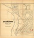
| Date: | 1910 |
|---|---|
| Description: | This map of Stevens Point shows the Wisconsin River, labeled plat additions, numbered lots, and some land ownership. An inset map in the bottom left corner... |
| Date: | 1852 |
|---|---|
| Description: | This map of Stevens Point shows lot numbers, land reservations for steam saw mill, and Shaurette Mills. The top right features an inset map: Sec. 31 & 32, ... |

| Date: | 1950 |
|---|---|
| Description: | This blueline print shows roads and proposed roads in parts of the Towns of Carson, Hull, Linwood, and Plover, as well as boundaries and lines demarking ex... |
If you didn't find the material you searched for, our Library Reference Staff can help.
Call our reference desk at 608-264-6535 or email us at: