 Filter: Categories of Wisconsin Historical Images
Filter: Community of Sheboygan Falls
Filter: Subject of human settlements
Filter: Subject of transportation
Filter: Categories of Wisconsin Historical Images
Filter: Community of Sheboygan Falls
Filter: Subject of human settlements
Filter: Subject of transportation
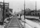
| Date: | 05 05 1905 |
|---|---|
| Description: | Observing the flood damage to railroad tracks in the business section of town. |
| Date: | |
|---|---|
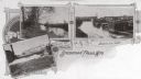
| Description: | Three scenes of the city. Captions read: "The Falls," "Scene on Sheboygan River" and "Bird's Eye View." |
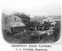
| Date: | 1878 |
|---|---|
| Description: | Elevated view of several buildings making up the Sheboygan Falls Tannery, which was owned by proprietor C.S. Weisse. Weisse is at the far right, standing w... |

| Date: | 1961 |
|---|---|
| Description: | This map shows wards as well as proposed future streets, lot and block numbers, additions, and some landownership. The Sheboygan River is labeled. |

| Date: | 1940 |
|---|---|
| Description: | This map hows block and lot numbers, water mains, roads, parks, the Sheboygan River and some landownership. |
If you didn't find the material you searched for, our Library Reference Staff can help.
Call our reference desk at 608-264-6535 or email us at:
