 Filter: Categories of Wisconsin Historical Images
Filter: Community of Sheboygan
Filter: Creator Name of Unknown
Filter: Year of 1800-1899
Filter: Categories of Wisconsin Historical Images
Filter: Community of Sheboygan
Filter: Creator Name of Unknown
Filter: Year of 1800-1899

| Date: | 1890 |
|---|---|
| Description: | Bird's-eye view of Sheboygan on an advertisement for Kempf's Magical Salve, distributed by E.J. Kempf, "Legitimate Bill Poster and Distributor." |

| Date: | 1880 |
|---|---|
| Description: | Winter scene of Sheboygan after a heavy snowfall. Mr. Henry C. Mueller can be seen on the top of the three-story building which he built in 1871. Many peop... |

| Date: | 1871 |
|---|---|
| Description: | Elevated view of South Twelfth Street. There is a child standing in the center of the street holding onto a wagon in which another child is sitting. A chur... |

| Date: | 1890 |
|---|---|
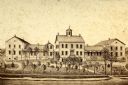
| Description: | View from road towards a mission house, erected between 1862 and 1873. |
| Date: | 1865 |
|---|---|
| Description: | View of a mission house, erected between 1862 and 1873. |
| Date: | 1863 |
|---|---|
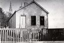
| Description: | Exterior view of M. Gottshalk's first meat market. |
| Date: | 1892 |
|---|---|
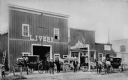
| Description: | Men posed in front of a livery barn and horse sales stable. |

| Date: | 1857 |
|---|---|
| Description: | This map of Sheboygan Harbor shows the river mouth and harbor, piers, wharfs, piles of old destroyed bridge wharfs, streets, and the lake shore from survey... |

| Date: | 1840 |
|---|---|
| Description: | This is a plat map of Sheboygan showing the Sheboygan River and Lake Michigan. Streets are labeled and plats are numbered in quadrants. Some points of inte... |

| Date: | 06 1899 |
|---|---|
| Description: | Two men and a woman pose on a wooden sidewalk in front of a bicycle livery with three bicycles. An awning is folded above the storefront, and signs and mer... |

| Date: | 1865 |
|---|---|
| Description: | This map shows the harbor with proposed extensions and the shore line as it appeared in 1865. Depths are shown by soundings. |

| Date: | 1857 |
|---|---|
| Description: | This map shows piers, wharves, streets, and the lake shore from the survey of August 1856. Lake Michigan and the Sheboygan River are labeled. Depths are sh... |
If you didn't find the material you searched for, our Library Reference Staff can help.
Call our reference desk at 608-264-6535 or email us at: