 Filter: Categories of Wisconsin Historical Images
Filter: Community of Richland Center
Filter: Subject of human settlements
Filter: Subject of land
Filter: Categories of Wisconsin Historical Images
Filter: Community of Richland Center
Filter: Subject of human settlements
Filter: Subject of land

| Date: | 1875 |
|---|---|
| Description: | Bird's-eye map of Richland Center. |
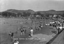
| Date: | 1930 |
|---|---|
| Description: | The municipal sand-bottomed swimming pool was a popular spot to cool off in the summer months. |
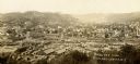
| Date: | 1900 |
|---|---|
| Description: | Elevated view of town from hill. Caption reads: "Birds Eye View Richland Center, Wis". |
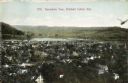
| Date: | 1911 |
|---|---|
| Description: | Elevated view of town, with a river and hills in the background. Caption reads: "Panoramic View, Richland Center, Wis." |
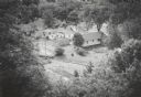
| Date: | 1965 |
|---|---|
| Description: | Elevated view from hill of houses and garages surrounded by trees. |
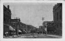
| Date: | 1910 |
|---|---|
| Description: | View down a business-lined street featuring a barber shop in the left foreground. Caption reads: "Richland Center, Wis." |
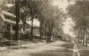
| Date: | 1925 |
|---|---|
| Description: | View along right curb towards the left side of the tree-lined street, where an automobile is parked. Caption reads: "No. Sheldon St. Richland Center Wis." |
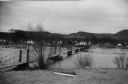
| Date: | 1945 |
|---|---|
| Description: | View of a footbridge over the Pine River. Boats are laying in the grass in the foreground. |

| Date: | 1925 |
|---|---|
| Description: | Elevated view of a footbridge over Pine River. Caption reads: "Footbridge and Pine River, Richland Center, Wisconsin". |
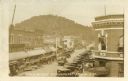
| Date: | 1927 |
|---|---|
| Description: | Elevated view of Main Street with automobiles lining either side. An ice cream parlor is visible on the right side, as are a dry cleaning and tailoring bu... |

| Date: | 1925 |
|---|---|
| Description: | West Side Footbridge. Caption reads: "West Side Footbridge Richland Center Wis." |
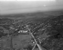
| Date: | 03 28 1949 |
|---|---|
| Description: | Aerial photographs of Richland Center, Wisconsin. |

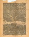
| Date: | 1903 |
|---|---|
| Description: | This map of Richland County, Wisconsin, shows land ownership and acreages, the township and range grid, sections, cities, towns and post offices, roads, ra... |
| Date: | 1903 |
|---|---|
| Description: | This topographical map from the U.S. Geological Survey shows parts of Richland, Sauk, Grant, and Iowa counties, Wisconsin, as of 1903. |

| Date: | |
|---|---|
| Description: | View over river with a small bridge in front of the Carnation Factory with tree-covered hills in the background. Dwellings and fields are in the far right ... |

| Date: | 1951 |
|---|---|
| Description: | This street map shows public buildings and streets. The lower left corner includes a table of street names and the middle right includes text on the street... |

| Date: | 1922 |
|---|---|
| Description: | Text on front reads: "Steamboat Rock, Richland Center, Wis." A large formation, crowned with trees, juts over a dirt road. An automobile is on the road on ... |

| Date: | 07 22 1947 |
|---|---|
| Description: | Text on front reads: "Natural Gateway, Rockridge, Near Richland Center, Wis." An automobile is driving on a dirt road between two large rock outcroppings. ... |

| Date: | 1945 |
|---|---|
| Description: | Text on front reads: "Meandering Stream Near Richland Center, Wis." Elevated view of a stream, probably the Pine River or a tributary, winding through a va... |
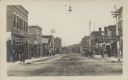
| Date: | 1909 |
|---|---|
| Description: | Text on front reads: "Street Scene, Richland Ctr., Wis." Pedestrians are walking on the sidewalks of a main street, with many businesses on each side. A st... |
If you didn't find the material you searched for, our Library Reference Staff can help.
Call our reference desk at 608-264-6535 or email us at: