 Filter: Categories of Wisconsin Historical Images
Filter: Community of Richland Center
Filter: Subject of cities and towns
Filter: Year of 1900-1999
Filter: Year of 1900-1909
Filter: Categories of Wisconsin Historical Images
Filter: Community of Richland Center
Filter: Subject of cities and towns
Filter: Year of 1900-1999
Filter: Year of 1900-1909
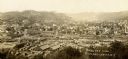
| Date: | 1900 |
|---|---|
| Description: | Elevated view of town from hill. Caption reads: "Birds Eye View Richland Center, Wis". |

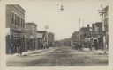
| Date: | 1900 |
|---|---|
| Description: | View looking down Main Street, filled with pedestrians and horse-drawn vehicles. Caption reads: "Main Street, Richland Center, Wis." |

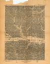
| Date: | 1903 |
|---|---|
| Description: | This map of Richland County, Wisconsin, shows land ownership and acreages, the township and range grid, sections, cities, towns and post offices, roads, ra... |
| Date: | 1903 |
|---|---|
| Description: | This topographical map from the U.S. Geological Survey shows parts of Richland, Sauk, Grant, and Iowa counties, Wisconsin, as of 1903. |
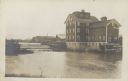
| Date: | 1909 |
|---|---|
| Description: | Text on front reads: "Parfrey's Mill and Dam. Richland Ctr. Wis." A grist mill, dam and millpond on the Pine River. More buildings are behind the mill. The... |
| Date: | 1909 |
|---|---|
| Description: | Text on front reads: "Street Scene, Richland Ctr., Wis." Pedestrians are walking on the sidewalks of a main street, with many businesses on each side. A st... |
If you didn't find the material you searched for, our Library Reference Staff can help.
Call our reference desk at 608-264-6535 or email us at: