 Filter: Categories of Wisconsin Historical Images
Filter: Community of Racine
Filter: Subject of rivers
Filter: Categories of Wisconsin Historical Images
Filter: Community of Racine
Filter: Subject of rivers

| Date: | 1874 |
|---|---|
| Description: | Bird's-eye map of Racine, with an inset of Racine College. |
| Date: | 1888 |
|---|---|
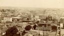
| Description: | Elevated view from the northwest of the Racine Court House. Caption reads: "Birds-Eye from Court House, Northwest." |
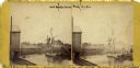
| Date: | 1869 |
|---|---|
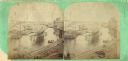
| Description: | A stereograph of an elevated view of the Root River. |
| Date: | 1885 |
|---|---|
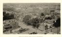
| Description: | Elevated view from tower of the Racine Court House looking north. A note at bottom center on the building of a roof reads, in part: "1st. Presby. Church. 1... |
| Date: | 1888 |
|---|---|
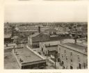
| Description: | Elevated view looking northwest from Racine City Hall. Caption reads: "Bird's-Eye View from City Hall, Northwest." |

| Date: | 1920 |
|---|---|
| Description: | Elevated view of Island Park, from Washington Park Drive, looking north from the west end of Kinzie Avenue bridge. |

| Date: | 1905 |
|---|---|
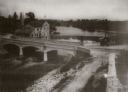
| Description: | Horlick Park, or Island Park, showing the Kinzie Avenue bridge. |

| Date: | 1906 |
|---|---|
| Description: | View of Horlick's mill and dam, also known as "Ye Old Mill." |

| Date: | 1929 |
|---|---|
| Description: | Panoramic view of Horlick's Malted Milk Corporation buildings. |
| Date: | 1858 |
|---|---|
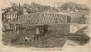
| Description: | Elevated view of the Fourth Street bridge with various buildings in the background. Caption reads: "The New Fourth Street Bridge, Racine, Wisconsin." |
| Date: | 1910 |
|---|---|
| Description: | Elevated view of a bridge in Racine next to the "Ye Old Horlick's Boat Livery". |

| Date: | 1907 |
|---|---|
| Description: | Text on front reads: "Racine, Wis. in 1850." Artist's rendering of the view of the harbor with sailing ships, sailboats, rowboats and canoes. The Main Stre... |

| Date: | 1972 |
|---|---|
| Description: | This map on 5 sheets features a title page sheet with business directory and shows section numbers, roads, railroads, saw mills, churches, blacksmith shops... |
| Date: | |
|---|---|
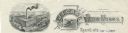
| Description: | Memohead of the J.I. Case Plow Works of Racine, Wisconsin, with an elevated view of the company plant and a smaller scene set on a scroll of a man driving ... |
| Date: | |
|---|---|
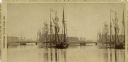
| Description: | Stereograph of lumber hooker ships in the Racine harbor on the Root River. The 4th St. bridge spans the river at left and the Racine Agricultural Works bui... |
| Date: | 1870 |
|---|---|
| Description: | View of a lumber hooker ship at dock on the Root River. The 4th St. bridge spans the river at center. The Racine Woolen Mill is visible at right behind the... |
| Date: | 1947 |
|---|---|
| Description: | This map of Racine has labeled streets, the Root River, Lake Michigan, and includes manuscript annotations of newly annexed areas and African-American neig... |

| Date: | 1956 |
|---|---|
| Description: | This map of Racine includes a street directory and index of public buildings. Streets, points of interest, Lake Michigan, and the Root River are labeled. A... |

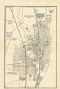
| Date: | 1950 |
|---|---|
| Description: | This map of Racine's business section is oriented with the north to the right and shows businesses and lot owners. Businesses, streets, and the Root River ... |
If you didn't find the material you searched for, our Library Reference Staff can help.
Call our reference desk at 608-264-6535 or email us at:
