Filter: Categories of Wisconsin Historical Images
Filter: Community of Racine
Filter: Subject of railroads
Filter: Categories of Wisconsin Historical Images
Filter: Community of Racine
Filter: Subject of railroads

| Date: | 1874 |
|---|---|
| Description: | Bird's-eye map of Racine, with an inset of Racine College. |
| Date: | |
|---|---|
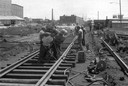
| Description: | Group of men repairing railroad track near Racine. |
| Date: | 1925 |
|---|---|
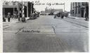
| Description: | View of the railroad crossing where rubber paving was used for the first time in the United States. Caption at top reads: "First Rubber Crossing in U.S. S.... |
| Date: | 1900 |
|---|---|
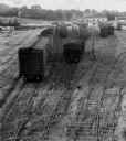
| Description: | View of the Racine and Mississippi freight and passenger depot with multiple individuals lined up on the platform. |

| Date: | 1910 |
|---|---|
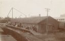
| Description: | View of the Chicago & Northwestern Railroad depot. A train rests at the stop while commuters wait to board from the platform. There is a horse to the right... |

| Date: | 1972 |
|---|---|
| Description: | This map on 5 sheets features a title page sheet with business directory and shows section numbers, roads, railroads, saw mills, churches, blacksmith shops... |

| Date: | 1904 |
|---|---|
| Description: | This map is mounted on cloth and shows streets, railways, and city wards. A stamp in the right margin reads: "The Library of Congress, one copy received Fe... |

| Date: | 1858 |
|---|---|
| Description: | This map shows lot and block numbers, landownership, buildings, railroads, roads, wards, points of interest, parks, and cemeteries. Also included are illus... |

| Date: | 01 18 1907 |
|---|---|
| Description: | This map shows Lake Michigan, streets, schools, churches, businesses, cemeteries, parks, and railroads. Relief is shown by contours; depths are shown by so... |

| Date: | 1867 |
|---|---|
| Description: | This map shows components of the bottom of Lake Michigan and the Root River, as well as the harbor, buildings, streets, railroads, and rural landowners in ... |
| Date: | 1900 |
|---|---|
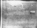
| Description: | This map shows plots and streets as well at the Root River. The bottom margin and back of the map include extensive certifications. |
If you didn't find the material you searched for, our Library Reference Staff can help.
Call our reference desk at 608-264-6535 or email us at: