 Filter: Categories of Wisconsin Historical Images
Filter: Community of Prairie du Chien
Filter: Subject of transportation
Filter: Categories of Wisconsin Historical Images
Filter: Community of Prairie du Chien
Filter: Subject of transportation

| Date: | 07 28 1934 |
|---|---|
| Description: | This map shows buildings and dimensions of Fort Crawford and hospital overlaid on a plat of existing lots, streets, and closed streets. |
| Date: | 1856 |
|---|---|
| Description: | This map is ink and watercolor on paper and includes certifications inscribed by Saml. T. [M?]ight, a civil engineer, Edward H. Brodhead, James H. Lockwood... |

| Date: | 1828 |
|---|---|
| Description: | This map is pen-and-ink and served as the model for the lithograph produced in 1828 by C.B. Graham. Landowners are labeled as is the Mississippi River. |
| Date: | 1912 |
|---|---|
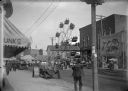
| Description: | View from sidewalk of a street carnival with tents, circus banners and a Ferris Wheel set up in the middle of the street. Signboards advertise ice cream an... |
| Date: | 1912 |
|---|---|
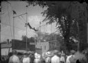
| Description: | View from crowd of a pair of trapeze acrobats performing at a street fair. |

| Date: | 1900 |
|---|---|
| Description: | This photocopy map shows blocks, lots, subdivisions, city wards, buildings, some landownership, and the Mississippi River. The map margins include business... |

| Date: | 1968 |
|---|---|
| Description: | Tourists boarding a paddle steamer along the Mississippi River. |

| Date: | |
|---|---|
| Description: | View down street towards a crowd of people, sitting or standing on the side of the street, or on top of the buildings, watching a parade. A firetruck from ... |
| Date: | 1873 |
|---|---|
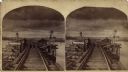
| Description: | Stereograph of John Lawler's pile-pontoon railway bridge over both channels of the Mississippi River at Prairie du Chien and McGregor, Iowa. The East Draw ... |
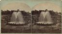
| Date: | |
|---|---|
| Description: | Stereograph of Artesian well. A stone wall surrounds the well, with an observation area beyond. Groups of visitors are milling about and a drive with horse... |
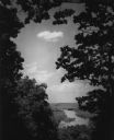
| Date: | 1950 |
|---|---|
| Description: | Elevated view of the Wisconsin River from Wyalusing State Park, framed by trees. There is a bridge over the river in the distance. |

| Date: | 1950 |
|---|---|
| Description: | View of an automobile traveling north on Highway 35, near the Mississippi River. Railroad tracks run between the road and the river. In the background are ... |
If you didn't find the material you searched for, our Library Reference Staff can help.
Call our reference desk at 608-264-6535 or email us at: