 Filter: Categories of Wisconsin Historical Images
Filter: Community of Prairie du Chien
Filter: Subject of transportation
Filter: Categories of Wisconsin Historical Images
Filter: Community of Prairie du Chien
Filter: Subject of transportation

| Date: | 1830 |
|---|---|
| Description: | This early 19th century manuscript map of Prairie du Chien, Wisconsin, shows sections, landownership and acreages, roads, and ferries in the towns of Bridg... |

| Date: | |
|---|---|
| Description: | "Section of New Prairie du Chien Marquette $1,000,000 Suspension Bridge. Total length 3729 feet. Only suspension bridge on the Mississippi River. Open for ... |

| Date: | |
|---|---|
| Description: | "Section of New Prairie du Chien Marquette $1,000,000 Suspension Bridge. Total length 3729 feet. Only suspension bridge on the Mississippi River. Open for ... |

| Date: | |
|---|---|
| Description: | View from shoreline of the "Capitol" excursion steamer pulled up to the bank of the Mississippi. The steamer has three or four decks, and elaborately detai... |

| Date: | |
|---|---|
| Description: | A man and two women pose in a four seat buggy. They are wearing suits, dresses and hats. Buildings and a fence appear in the background. |
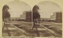
| Date: | 1875 |
|---|---|
| Description: | Stereograph view of Black Hawk Avenue. |

| Date: | 1859 |
|---|---|
| Description: | Steam-powered car designed to run on ice across the Mississippi River at Prairie du Chien. The LADY FRANKLIN made one successful trip across, but wa... |

| Date: | 1882 |
|---|---|
| Description: | This map is ink on cardboard and shows the location of military forts over the course of years. Also shown are points of interest, streets, the Mississippi... |

| Date: | 1864 |
|---|---|
| Description: | This map is ink, pencil, and color on paper and shows numbered lots and labeled streets. The bottom margin of the map reads: "Recorded in the Registry of d... |

| Date: | 1950 |
|---|---|
| Description: | Intended for tourists, this brochure features two maps with tourists sites along the Mississippi River. One map shows roads and populated places along the ... |

| Date: | 1976 |
|---|---|
| Description: | This map includes an index of streets, government and historic buildings, hospitals, schools, places of recreation, churches, cemeteries, and other miscell... |

| Date: | 1830 |
|---|---|
| Description: | This map is ink, color, and pencil on paper and shows streets, farm lots, and a church. Handwritten notes are at the bottom of the map and are very light. |

| Date: | 1838 |
|---|---|
| Description: | This map is a development plat that shows street names, numbered blocks and lots, and small farm lot owners. Included on the right of the map is a large am... |

| Date: | 06 1853 |
|---|---|
| Description: | This map is ink, pencil, and color on paper and shows lot and block numbers and dimensions, sold lots, streets, and the Mississippi River. Some lots are co... |

| Date: | 1856 |
|---|---|
| Description: | This map shows lot and block numbers, streets, the Mississippi River, Fort Crawford, depot ground, and a graveyard. An old fort location is outlined in red... |

| Date: | 1857 |
|---|---|
| Description: | This map shows lots and streets and includes pencil manuscript notations on the front and certification statements on the reverse. The top left margin read... |

| Date: | 1858 |
|---|---|
| Description: | This map shows streets, lots, and landownership. Also included are notations in pencil and blue colored pencil. Some lots are colored in blue, green, or br... |

| Date: | 1855 |
|---|---|
| Description: | This map shows streets and lots. The right side of the map includes notes on widths of streets and certifications. The top right reads: "Parish's Addition ... |

| Date: | 1865 |
|---|---|
| Description: | This is a collection of two plat maps. The first map shows lots, streets, and farm lot 25. Written in ink, the top of the map reads: Plat of Prairie du Chi... |

| Date: | 1856 |
|---|---|
| Description: | This map shows lot and block numbers, streets, depot building, and the Milwaukee & Mississippi Rail Road. |
If you didn't find the material you searched for, our Library Reference Staff can help.
Call our reference desk at 608-264-6535 or email us at: