 Filter: Categories of Wisconsin Historical Images
Filter: Community of Poynette
Filter: Subject of human settlements
Filter: Categories of Wisconsin Historical Images
Filter: Community of Poynette
Filter: Subject of human settlements
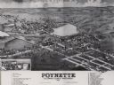
| Date: | 1882 |
|---|---|
| Description: | Bird's-eye map of Poynette, with one vignette. |
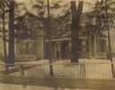
| Date: | 1900 |
|---|---|
| Description: | Elijah Hinkson residence, with a fence in the foreground. Snow is on the ground. |
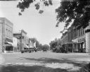
| Date: | 1929 |
|---|---|
| Description: | View down street at intersection of commercial buildings on both sides. On the left is a drug store/soda fountain, restaurant and a cafe. On the right is a... |
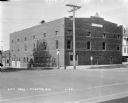
| Date: | 1929 |
|---|---|
| Description: | View from street of City Hall building on a corner. There are garages in the back on the left. On the corner there is a stop sign, a Hwy 51 signpost, and a... |

| Date: | 1956 |
|---|---|
| Description: | This map shows Lake Wisconsin, roads, highways, parks, resort areas, camps, gardens, and Wisconsin State experimental game and fur farm. The back of the ma... |

| Date: | 1900 |
|---|---|
| Description: | This photocopy plat map of Pauquette, now Poynette, shows streets and lot numbers. |

| Date: | 04 24 1970 |
|---|---|
| Description: | Group of people outdoors behind a fence at a rock festival. |
If you didn't find the material you searched for, our Library Reference Staff can help.
Call our reference desk at 608-264-6535 or email us at: