Filter: Categories of Wisconsin Historical Images
Filter: Community of Portage
Filter: Year of 1900-1999
Filter: Subject of transportation
Filter: Categories of Wisconsin Historical Images
Filter: Community of Portage
Filter: Year of 1900-1999
Filter: Subject of transportation

| Date: | 1936 |
|---|---|
| Description: | This map is red and black ink on tracing cloth and is oriented with north to the upper left. This hand-drawn map shows a central portion of the military ro... |

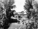
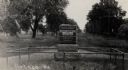
| Date: | 1910 |
|---|---|
| Description: | View down the canal, with buildings along the shoreline, and a boat coming down the canal. |
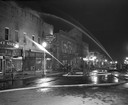
| Date: | 04 15 1950 |
|---|---|
| Description: | Fire fighters from neighboring communities help put out at a nighttime fire in the downtown business district. |
| Date: | 1900 |
|---|---|
| Description: | Sheriff John MacKenzie poses in front of the Portage jail with his staff. |
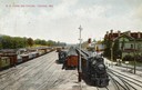
| Date: | 1909 |
|---|---|
| Description: | Elevated view of the railroad yards and station. Caption reads: "R. R. Yards and Station, Portage, Wis." |
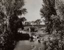
| Date: | 1935 |
|---|---|
| Description: | Elevated view of the Portage canal and lock, with the Indian Agency House in the center background. The canal was dug in 1849 as part of the Fox-Wisconsin ... |
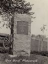
| Date: | 1925 |
|---|---|
| Description: | The Red Bird monument, erected on the site of Ft. Winnebago and Red Bird's surrender. There is a cannon on the lawn behind the monument. A road is along th... |
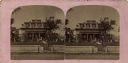
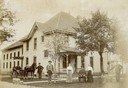
| Date: | 1910 |
|---|---|
| Description: | Stereograph of the Purdy house. View from street towards the house, with a stone wall along the sidewalk. |

| Date: | 1925 |
|---|---|
| Description: | The Pierre Pauquette monument located at the easterm terminus of the Wauona Trail. Erected by the Wau-bun Chapter of the Daughters of the American Revoluti... |
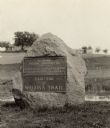
| Date: | 1925 |
|---|---|
| Description: | A view of the Pierre Pauquette monument located at the eastern terminus of the Wauona Trail. Erected by the Wau-bun Chapter of the Daughters of the America... |
| Date: | 1910 |
|---|---|
| Description: | A view of the Jacques Marquette and Louis Joliet marker. "This tablet marks the place near which Jacques Marquette and Louis Joliet entered the Wisconsin R... |
| Date: | 1932 |
|---|---|
| Description: | Indian Agency House near the site of Fort Winnebago. |
| Date: | 1935 |
|---|---|
| Description: | Elevated view of the Indian Agency House near the site of Fort Winnebago. View of Portage Canal in foreground. The canal was dug in 1849 as part of the Fox... |

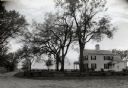
| Date: | 1936 |
|---|---|
| Description: | A view of the Indian Agency house after restoration. A person is standing on the porch. |
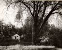
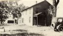
| Date: | 1962 |
|---|---|
| Description: | A view of a house beside the canal, from the south side. |
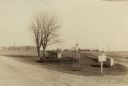
| Date: | 1924 |
|---|---|
| Description: | Fort Winnebago monument two miles east of Portage on Highway 33, erected by the Wau-bun Chapter of the Daughters of the American Revolution in 1924. The mo... |
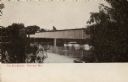
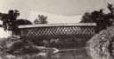
| Date: | 1900 |
|---|---|
| Description: | Covered bridge over river. Caption reads: "The Old Bridge, Portage, Wis." |
If you didn't find the material you searched for, our Library Reference Staff can help.
Call our reference desk at 608-264-6535 or email us at: