Filter: Categories of Wisconsin Historical Images
Filter: Community of Portage
Filter: Year of 1800-1899
Filter: Categories of Wisconsin Historical Images
Filter: Community of Portage
Filter: Year of 1800-1899
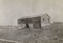
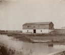
| Date: | 1898 |
|---|---|
| Description: | Ruins of the commissary warehouse at Fort Winnebago, about 1898. Fort Winnebago was closed in 1845 and the land and buildings sold. Today, only the Surgeon... |
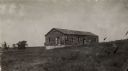
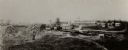
| Date: | 1898 |
|---|---|
| Description: | The commissary warehouse at Fort Winnebago. |
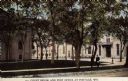
| Date: | 1890 |
|---|---|
| Description: | View across street towards the Columbia County Court House and Post Office. Caption reads: "Court House and Post Office at Portage, Wis." |
| Date: | 1870 |
|---|---|
| Description: | Stereograph of the Columbia County Jail. People are on the sidewalk near the entrance. |
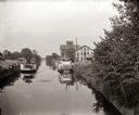
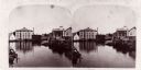
| Date: | 1885 |
|---|---|
| Description: | Steamboats docked in the Portage Canal, which was hand dug beginning in 1849 and completed in 1851. There are industrial buildings on either side of the ca... |
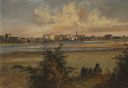
| Date: | 1856 |
|---|---|
| Description: | "After painting a number of Fox River scenes, "the artists continued their way to Fond du Lac, at the south end of Lake Winnebago, where they found some mo... |
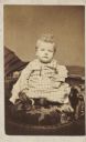
| Date: | 1880 |
|---|---|
| Description: | Carte-de-visite studio portrait of a small child sitting in a chair. |
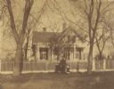
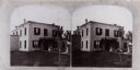
| Date: | 1870 |
|---|---|
| Description: | View across road of the Clough house, residence of Mr. and Mrs. Willoughby. A man is standing and holding the hands of two young girls in front of the fenc... |

| Date: | 1800 |
|---|---|
| Description: | This map shows the land claim owned by the Portage Canal Company and includes an index of landownership and landmarks. The Wisconsin and Portage River, the... |

| Date: | 1800 |
|---|---|
| Description: | This map is pencil on tracing paper and shows marshes, the Wisconsin River, Indian trails, and Indian boundary line. The upper left corner reads: "Let sect... |

| Date: | 1836 |
|---|---|
| Description: | This map shows lot and block numbers, streets, a proposed canal basin, Fort Winnebago, and the Wisconsin and Fox Rivers. Relief is shown by hachures and no... |

| Date: | 1855 |
|---|---|
| Description: | This map shows landownership, lot and block numbers, streets, a canal, bridges, Fort Winnebago, the Wisconsin River, and the Fox River. Relief is shown by ... |
If you didn't find the material you searched for, our Library Reference Staff can help.
Call our reference desk at 608-264-6535 or email us at: