 Filter: Categories of Wisconsin Historical Images
Filter: Community of Portage
Filter: Subject of wisconsin river (wis.)
Filter: Categories of Wisconsin Historical Images
Filter: Community of Portage
Filter: Subject of wisconsin river (wis.)

| Date: | 1936 |
|---|---|
| Description: | This map is red and black ink on tracing cloth and is oriented with north to the upper left. This hand-drawn map shows a central portion of the military ro... |
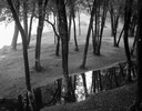
| Date: | 09 22 1962 |
|---|---|
| Description: | Elevated view of trees and pool of water near the Wisconsin River in Pauquette Park. |

| Date: | 1868 |
|---|---|
| Description: | Bird's-eye map of Portage, with insets of the Court House and the Public School. |
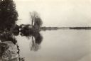
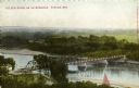
| Date: | 1935 |
|---|---|
| Description: | The Wisconsin River looking downstream. The Wisconsin River end of the canal may be seen at the left. |
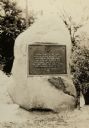
| Date: | 1928 |
|---|---|
| Description: | The Pierre Pauquette monument, located on the bank of the Wisconsin River where he operated a ferry between the years 1828 and 1836. Erected by the Wau-bun... |
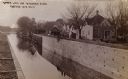
| Date: | 1910 |
|---|---|
| Description: | The Portage Canal at the Wisconsin River, showing the upper lock. Caption reads: "Upper Lock and Wisconsin River Portage Wis. No. 10". A group of people ar... |

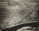
| Date: | 1945 |
|---|---|
| Description: | An aerial view of the Portage Canal, Fox and Wisconsin Rivers. |
| Date: | 1900 |
|---|---|
| Description: | Elevated view of a bridge over the Wisconsin River. Caption reads: "The New Bridge on the Wisconsin, Portage, Wis." |
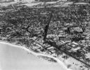
| Date: | 1945 |
|---|---|
| Description: | An elevated view of Portage and it's vicinity. |
| Date: | 02 09 1949 |
|---|---|
| Description: | One of five aerial views of Portage, including the frozen Wisconsin River. |

| Date: | 1800 |
|---|---|
| Description: | This map is pencil on tracing paper and shows marshes, the Wisconsin River, Indian trails, and Indian boundary line. The upper left corner reads: "Let sect... |

| Date: | 1920 |
|---|---|
| Description: | This street map was likely given out by the Rebholz Company: Clothiers and Furnishers. The map shows labeled streets, train tracks, Silver Lake, Mud Lake, ... |

| Date: | 1836 |
|---|---|
| Description: | This map shows lot and block numbers, streets, a proposed canal basin, Fort Winnebago, and the Wisconsin and Fox Rivers. Relief is shown by hachures and no... |

| Date: | 1855 |
|---|---|
| Description: | This map shows landownership, lot and block numbers, streets, a canal, bridges, Fort Winnebago, the Wisconsin River, and the Fox River. Relief is shown by ... |

| Date: | 10 1961 |
|---|---|
| Description: | View from hill towards cars driving over a bridge spanning the Wisconsin River (I90/I94/I39). |
If you didn't find the material you searched for, our Library Reference Staff can help.
Call our reference desk at 608-264-6535 or email us at: