Filter: Categories of Wisconsin Historical Images
Filter: Community of Portage
Filter: Subject of water
Filter: Categories of Wisconsin Historical Images
Filter: Community of Portage
Filter: Subject of water

| Date: | 1936 |
|---|---|
| Description: | This map is red and black ink on tracing cloth and is oriented with north to the upper left. This hand-drawn map shows a central portion of the military ro... |

| Date: | 1910 |
|---|---|
| Description: | View down the canal, with buildings along the shoreline, and a boat coming down the canal. |

| Date: | 1831 |
|---|---|
| Description: | Drawing of Fort Winnebago (near present-day Portage) that illustrated "Wau-Bun," Juliette Kinzie's memoir of her experiences on the early Wisconsin fronti... |
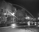
| Date: | 04 15 1950 |
|---|---|
| Description: | Fire fighters from neighboring communities help put out at a nighttime fire in the downtown business district. |
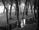
| Date: | 09 22 1962 |
|---|---|
| Description: | Elevated view of trees and pool of water near the Wisconsin River in Pauquette Park. |

| Date: | 1868 |
|---|---|
| Description: | Bird's-eye map of Portage, with insets of the Court House and the Public School. |
| Date: | 1935 |
|---|---|
| Description: | Elevated view of the Portage canal and lock, with the Indian Agency House in the center background. The canal was dug in 1849 as part of the Fox-Wisconsin ... |
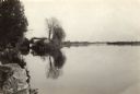
| Date: | 1935 |
|---|---|
| Description: | The Wisconsin River looking downstream. The Wisconsin River end of the canal may be seen at the left. |

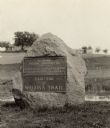
| Date: | 1925 |
|---|---|
| Description: | The Pierre Pauquette monument located at the easterm terminus of the Wauona Trail. Erected by the Wau-bun Chapter of the Daughters of the American Revoluti... |
| Date: | 1925 |
|---|---|
| Description: | A view of the Pierre Pauquette monument located at the eastern terminus of the Wauona Trail. Erected by the Wau-bun Chapter of the Daughters of the America... |
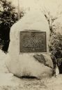
| Date: | 1928 |
|---|---|
| Description: | The Pierre Pauquette monument, located on the bank of the Wisconsin River where he operated a ferry between the years 1828 and 1836. Erected by the Wau-bun... |
| Date: | 1935 |
|---|---|
| Description: | Elevated view of the Indian Agency House near the site of Fort Winnebago. View of Portage Canal in foreground. The canal was dug in 1849 as part of the Fox... |
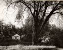
| Date: | 1962 |
|---|---|
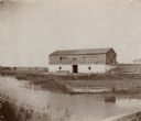
| Description: | A view of a house beside the canal, from the south side. |

| Date: | 1855 |
|---|---|
| Description: | Fox-Wisconsin portage and canal map, when the canal was not yet built. From a map in the office of the city clerk at Portage. "The old trail, the location ... |

| Date: | 1831 |
|---|---|
| Description: | Fort Winnebago, a print published in Mrs. John H. Kinzie's Wau-bun (1856). |
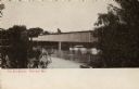
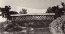
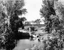
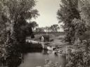
| Date: | 1900 |
|---|---|
| Description: | Covered bridge over river. Caption reads: "The Old Bridge, Portage, Wis." |
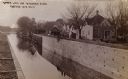
| Date: | 1910 |
|---|---|
| Description: | The Portage Canal at the Wisconsin River, showing the upper lock. Caption reads: "Upper Lock and Wisconsin River Portage Wis. No. 10". A group of people ar... |
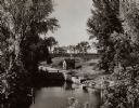
| Date: | 1935 |
|---|---|
| Description: | A view of the Portage Canal and lock. The Indian Agency House in the center background. The canal was dug in 1849 as part of the Fox-Wisconsin waterway pro... |
If you didn't find the material you searched for, our Library Reference Staff can help.
Call our reference desk at 608-264-6535 or email us at: