 Filter: Categories of Wisconsin Historical Images
Filter: Community of Portage
Filter: Subject of streets
Filter: Categories of Wisconsin Historical Images
Filter: Community of Portage
Filter: Subject of streets
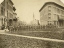
| Date: | 06 1877 |
|---|---|
| Description: | The Guppey Guard, a Wisconsin state militia unit, in formation on a street in Portage. |
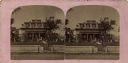
| Date: | 1910 |
|---|---|
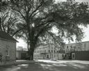
| Description: | Stereograph of the Purdy house. View from street towards the house, with a stone wall along the sidewalk. |
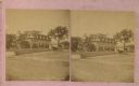
| Date: | 1880 |
|---|---|
| Description: | Stereograph of the Purdy house. Angled view from street towards the right side of the house, with a horse-drawn buggy. |
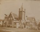
| Date: | |
|---|---|
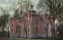
| Description: | The First Presbyterian Church, dedicated October 15, 1893. There are horse-drawn carriages parked across the street on the left. People are standing near t... |
| Date: | |
|---|---|
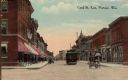
| Description: | View looking down Cook Street looking east. Caption reads: "Cook St. East, Portage, Wis." |
| Date: | 1905 |
|---|---|
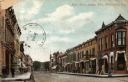
| Description: | Colorized postcard of a view of Cook Street. Caption reads: "Cook Street, Portage, Wis." |
| Date: | 1905 |
|---|---|
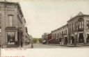
| Description: | View toward intersection. Caption reads: "Main Street looking West, PORTAGE, Wisc." |
| Date: | 1905 |
|---|---|
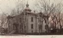
| Description: | View across street towards the Columbia County Court House. Caption reads: "Columbia Co. Court House, Portage, Wis." |
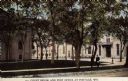
| Date: | 1890 |
|---|---|
| Description: | View across street towards the Columbia County Court House and Post Office. Caption reads: "Court House and Post Office at Portage, Wis." |
| Date: | 1900 |
|---|---|
| Description: | View across street towards the Columbia County Court House. Caption reads: Court House, Portage, Wisc." |
| Date: | 09 01 1962 |
|---|---|
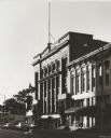
| Description: | View from street of City Hall and the corner of Clark Street at sundown. |
| Date: | 09 01 1962 |
|---|---|
| Description: | Exterior view of the factories at the corner of Thompson and Hullett Streets. A large tree grows at the curb. |

| Date: | 1920 |
|---|---|
| Description: | This street map was likely given out by the Rebholz Company: Clothiers and Furnishers. The map shows labeled streets, train tracks, Silver Lake, Mud Lake, ... |

| Date: | 1836 |
|---|---|
| Description: | This map shows lot and block numbers, streets, a proposed canal basin, Fort Winnebago, and the Wisconsin and Fox Rivers. Relief is shown by hachures and no... |

| Date: | 1855 |
|---|---|
| Description: | This map shows landownership, lot and block numbers, streets, a canal, bridges, Fort Winnebago, the Wisconsin River, and the Fox River. Relief is shown by ... |
If you didn't find the material you searched for, our Library Reference Staff can help.
Call our reference desk at 608-264-6535 or email us at:
